| Author |
Message |
    
muskyman
| | Posted on Wednesday, January 15, 2003 - 11:43 am: | 


|
I have heard of a "great trail" from grand junction to moab that is suposed to be a really nice 2 day trip. this May I plan on meeting up with one of my buddies that just moved south of grand juntion then hopefully do this trail spend a couple days in Moab then on to the maze then reverse order back to grand junction.
anyone have any info on this trail/road? I first read about it years ago and any help would be very welcome
thom |
muskyman
| | Posted on Wednesday, January 15, 2003 - 11:47 am: |
|
it is also called the Kokopelli, Grand Junction to Moab trail i'v heard? |
Blue (Bluegill)
| | Posted on Wednesday, January 15, 2003 - 12:01 pm: |
|
I don't know anything about it, but do you know if it's a difficult trail? I'll be driving back down from Denver to Phx in a few weeks, and I'd like to get off the damn highway. I'll be fully loaded & pulling a small uhaul trailer, though, so dirt road safari is about all I can handle... |
muskyman
| | Posted on Wednesday, January 15, 2003 - 12:10 pm: |
|
blue,
I have heard different things from different people...its suposed to have become a pretty popular mt bike trip I'v heard?, but I have also heard it has some really great 4x4 sections. the first time I heard of it the 4wheel and sport utility magazine guys did it(back in 93) and they decribed it as the best kept secret in CO and UT?
because where my buddie lives it just looks(on a map) as the most fun way to get to Moab we will have a smattering of trucks when/if we do it.
maybe you can go scout it for us?...its said to be 142 miles long
thom |
Dave_Lucas (Dave_Lucas)
| | Posted on Wednesday, January 15, 2003 - 12:19 pm: |
|
Hi Musky,
I went on a trail in Moab by the name of Kokopelli trail, but we did not end up in Grand Junction but that is not a big surprise since the trails in Moab twist all over the place.
I am about 4.5 hours from Grand Junction and about 6 hours from Moab, so if you want someone to tag along, Or maybe meet up and run a trail in Moab just let me know. |
Dave_Lucas (Dave_Lucas)
| | Posted on Wednesday, January 15, 2003 - 12:23 pm: |
|
http://www.co.blm.gov/gjra/kokopelli.html |
Axel Haakonsen (Axel)
| | Posted on Wednesday, January 15, 2003 - 12:37 pm: |
|
I have heard of that trail, too. I belive Bill Burke had an event running it once, you may want to check his website. |
Blue (Bluegill)
| | Posted on Wednesday, January 15, 2003 - 01:06 pm: |
|
from Dave's link (my bold):
"Kokopelli Bike Trail is 140 miles in length and winds through remote desert sandstone and shale canyons from Grand Junction, Colorado to Moab, Utah. The trail consists of single track, county road and 4X4 sections. Much of the trail can be traveled by vehicle or 4X4s, however the entire trail cannot be driven from beginning to end. The trail is marked by brown fiberglass posts set approximately every 1/2 mile and at intersections."
"Our free Kokopelli Trail brochure offers very detailed description of the trail, with a map showing camp sites, support vehicle points and trail designation."
I wonder how much you can drive? My primary goal must be forward progress, i.e. getting from Grand Junction to Moab. But a "short-cut" would be great  |
muskyman
| | Posted on Wednesday, January 15, 2003 - 01:22 pm: |
|
I have read that part that says you cant drive the whole trail but yet I have read where paople have done the whole thing?...hence my question
maybe you need to use other trails to avoid the bike only stretches?
Dave, I'm a very "more the merrier" kinda guy so yes you would be very welcome to join us
thom |
Blue (Bluegill)
| | Posted on Wednesday, January 15, 2003 - 06:14 pm: |
|
have to look into this more.......will post what I find... |
Kyle
| | Posted on Wednesday, January 15, 2003 - 09:18 pm: |
|
I have heard of that as well . I think George brought it up once and I believe it was pretty much a scenic dirt road (EXtreeeme for the MAR people) and it did indeed go all the way into Moab. Maybe you have to get onto another trail or something to come out ?
Kyle |
Rich Lee
| | Posted on Wednesday, January 15, 2003 - 09:56 pm: |
|
Guys,
I drove a route from Grand Junction to Moab with the LRNA trip in 1996. I will have to spend some time reviewing my maps to give more detail, as it is definately NOT the Kokopelli bike trail. This route starts in the suburbs just southwest of Grand Junction(south of Colorado National Monument and Uncomphagre (sp?) National Forrest).The route follows dirt roads over ridges and valleys, mostly due west until you are north of the Dolores River.
You then ford the Dolores river and continue up a ridge (more challenging) until you reach a spectacular bluff (Waring Mesa?) with 500' to 1000' sheer cliff that overlooks Valleys and the La Sal Mts. to the south. You then traverse this ridge eastward until you reach the top of Cottonwood Canyon and Rose Garden Hill.
You descend (westward) down Rose Garden Hill (rated 3+ going down and 4 going up)until you reach the roads and trails near Onion Creek. You are then on gravel/dirt roads until you reach the highway just north of Moab.
We left Grand Junction at sunrise in mid October and only stopped for a brief break after the ford and for 1 hour of lunch atop the Mesa. We arrived in Moab shortly after sunset the same day.
As I recall, we spent less than 30 minutes on pavement, about 3 hours on trails requiring a real 4x4, and the remainder on dirt roads through spectacularly beautiful sceenery where we met no other vehicles outside of town.
If you know the area, or are good at reading maps, you should be able to piece together this route from my description. I will try to provide some detail (and maybe some pictures) later.
Well worth the drive. |
muskyman
| | Posted on Wednesday, January 15, 2003 - 10:14 pm: |
|
well from what I have read about it there is no doubt long stretches that are just breathtakingly scenic 2 tracks hell its 140 miles it better have some easy spots or it will take a year. but I also read there are many obstacles that the mt bikers need to carry there bikes up and down and that even the most expierienced wheelers will appreciate. the article also had a number of good pics and it mentioned that most all the obstacles have no bypass. either way i am really not looking at it as the destination more of a apetizer instead of the highway.i should know more pretty soon my buddy that just moved out there has wheeling family that has lived there for 20 years and he says he will have all the details soon |
Dave_Lucas (Dave_Lucas)
| | Posted on Wednesday, January 15, 2003 - 11:31 pm: |
|
musky,
Let me know when you decide on a date and location and I will see if I can get off work.
Sounds like fun |
muskyman
| | Posted on Wednesday, January 15, 2003 - 11:40 pm: |
|
will do dave
thanks rich, sounds awsome!
this is sounding more and more like a must do
thom |
Rich Lee
| | Posted on Thursday, January 16, 2003 - 01:47 am: |
|
Musky,
Bear in mind, the route I took is not the Kokopelli trail. This route was further south and mostly dirt roads, save for the 4x4 section down from the Mesa. That was the only place that required spotting. It was the first "serious" wheeling I had done in a Disco. What I remember most about going down Rose Garden was one steep place where the Disco in front of us stopped because the student/driver was worried about how far the truck was leaning to one side during the steep descent (at least 15 degrees). At which point, Lea Magee and a much bigger LRNA instructor got out, grabbed the DOWNHILL roof rack rail and began rocking the truck,really hard, to the downhill side, while singing some sick variation of "Rawhide". i.e.
"Rollin rollin rollin, tho' the streams are swollen, keep them, Rovers rollin, RAWHIDE!
Through all kinds of weather,
(it was raining and snowing that day)
with burled wood and leather,
with my instructor by my side....
My heart's anticipatin' a cold one will be waitin'
be waitin at the end of my ride
Move em' on!
Head em' out!
Move em' on !
Head em' out!
Move em' on !
Head em' out!
Rawhide! "........
.......You get the picture. I expect you to take this further and produce a scenic Moab Musical video during your trip in May.
Oh, and be mindful of the ford across the Delores River, it might be in flood stage that time of year. |
Rob Davison (Pokerob)
| | Posted on Thursday, January 16, 2003 - 10:52 am: |
|
kyle,
that salt flat part or your rubi-dusi trip looked like some pretty extreme wheeling too.. pussy, a real man
wheels nothing but the Armageddon stuff the whole time.
bunch of rookie amateurs 'round these parts
rd |
muskyman
| | Posted on Thursday, January 16, 2003 - 11:01 am: |
|
i'll work on the song rich...lol
rob , I'm with you. this will be my wifes first trip and spending 140 miles on 2 tracks will be a good warm up for her before Moab.
part of destination wheeling IMO is taking it all in not just looking for places to break . If all you want to do is break shit and do the toughest stuff imaginable I know some quarries that will humble anybody...and I mean anyboby. |
Dave_Lucas (Dave_Lucas)
| | Posted on Thursday, January 16, 2003 - 03:32 pm: |
|
Musky,
What vehicle are you going to drive? |
thom mathie (Muskyman)
| | Posted on Thursday, January 16, 2003 - 04:29 pm: |
|
dave,
I plan on taking my disco but I have a number of things to make it trail ready that need to be done. other then it there will be a smattering such as
this
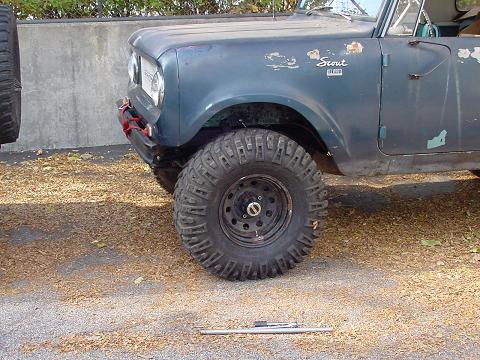
and this
and this one
and this one too
and it sounds like one of my buddies now wants to drive this wreck as well
and we will have all the tools and welders and shit it takes to keep such a rag tag bunch togather
thom |
Dave_Lucas (Dave_Lucas)
| | Posted on Thursday, January 16, 2003 - 04:56 pm: |
|
Wow,
Hope my poor little DII can keep up
Is that a toyota hilux truck? What are the details on it? |
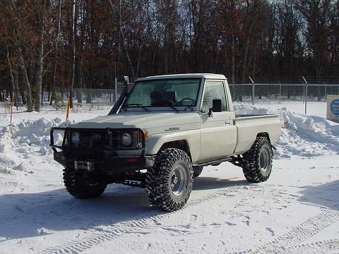
muskyman
| | Posted on Thursday, January 16, 2003 - 05:23 pm: |
|
its a FJ75 1 ton mining truck with a custom stainless steal bed. it has a diesel engine ARB's front and rear and 35 x 13.5 baja claws.8274 warn in a ARB bullbar.
I'm sure your D2 will have no problem keeping up if not doing better then most, these disco's are pretty damn competant right outa the wrapper. hell living as close as you do maybe you'l have to lead the way! |
Kyle
| | Posted on Thursday, January 16, 2003 - 06:55 pm: |
|
Rob , the black rock was simply a hotel for the night...
Kyle |
Rich Lee
| | Posted on Thursday, January 16, 2003 - 07:00 pm: |
|
Musky,
I'm serious about you doing this route with your wife, it's spectacular, but I'm worried about the river ford. In October the average flow on the Dolores is under 300 cubic feet per second. It was running 300 to 400 cfs when we drove through in (bumper height water). In May it averages over 3000 cfs. Got Snorkel? Unfortunatey, this ford is the key to a "pure" off-pavement trip. The ford is at a guaging station with these UTM coordinates:
Zone 12
656864 East
4295404 North
Plug these into the search link at topozone:
www.topozone.com and you will get a map of the area. From there, you can probably piece together the entire route.
For real time flows, check out this link:
http://waterdata.usgs.gov/ut/nwis/uv?09180000
For avg. monthly flows on the Dolores River,
go to this link at the USGS real-time water flow site:
http://waterdata.usgs.gov/ut/nwis/monthly/?site_no=09180000&agency_cd=USGS
It's nice to know before you go
BTW: Before you go, here are some recommended Books:
By Edward Abbey,
"Desert Solitaire"
"The Monkeywrench Gang"
"Heyduke Lives"
By Tony Hillerman:
"Skinwalkers"
"Thief of Time"
"The Fallen Man" (Villan drives a Range Rover)
Also, check out this link on the History of
Uranium mining in the Area.
http://historytogo.utah.gov/uranium.html
At One time Moab was "the wealthiest city in America" |
muskyman
| | Posted on Thursday, January 16, 2003 - 09:39 pm: |
|
wow! thanks rich, looks like I have my off-line reading for the rest of this winter.
I will look into the fording info,rivers can be scarry things. with a increase of x10 that you mention for May it just might be unpassable snorkle or not. we do run snorkles and do rivers very often but with 2 weeks of gear onboard my wife and daughter I will be very conservative.
I am really starting to look forward to this part of the trip,today I talked with a friends younger brother who rode part of the Kokopelli last year in may on a mt bike and he said it was just amazing as far as scenery goes.
thanks for all the info, I owe you one! |
Jaime (Blueboy)
| | Posted on Friday, January 17, 2003 - 03:02 pm: |
|
hey Thom,
when are you going to be in Moab?? a group of us will be there week of May 11th.
Jaime |
muskyman
| | Posted on Friday, January 17, 2003 - 03:42 pm: |
|
Jaime,
I believe our campsites in the maze are 7,8,9,10th so that should put us in Moab 5th,6th and again 11th and 12th. but I will have to ask my buddie that reserved the campsites just to make sure. we really are now looking into the grand junction to moab thing real serious so that could also change if we are there the 5th, 6th
make any sence?
thom |
Jaime (Blueboy)
| | Posted on Friday, January 17, 2003 - 03:53 pm: |
|
yep.
we will be staying at one of the campgrounds just not sure yet which one. arrive the 10th. it would be cool to at least say hello if we're both there.
this grand junction trail sounds very cool. anxious to learn if you end up on it.
Jaime |
andythoma
| | Posted on Friday, January 17, 2003 - 04:43 pm: |
|
Thom,
I rode the whole Kokopelli trail two years ago. Lots of fun on a mtbike. A truck could fit in sections, the parts that you couldn't I'm sure some planing with a usgs map could get you around anything. I was actually going to moab this weekend. The snow sucks here in Salt Lake City so I figured I'll go rock climbing. The nice thing about the moab area is there is aways another route if needed. If we don't get a major amount of snow here in Utah, the river crossing may not be that big of a deal come spring. I'd say plan around it and use those links to figure out if its doable close to the time. I'd be interested tagging along, since I live in slc 3.5hrs away. I could offer a stopping point going north or south if anyone needed it. Also if anyone else would want to meet in Moab, I love going there.
Andy |
muskyman
| | Posted on Friday, January 17, 2003 - 05:33 pm: |
|
just got off the phone and the camp sites are actually May 3,4,5,6,7, in the maze.so looks like it would make the most sence to go to the maze then back track to moab thru the 10th or 11th then follow that trail back to grand junction to end the trip.
it would be great to hook up with everbody for what ever part of the time they could make. we have enough campsites for 6 trucks in the maze but we are very flexible we may not even spend that much time on that side. |
Dave_Lucas (Dave_Lucas)
| | Posted on Friday, January 17, 2003 - 07:14 pm: |
|
Musky,
Please excuse my ignorance, but what is the Maze that you are referring to? |
muskyman
| | Posted on Friday, January 17, 2003 - 10:36 pm: |
|
its a area in Canyonlands National Park west of the Colorado river and south of the Green river. Its pretty tame wheeling mostly two tracks some easy switch back trails . a couple fun spots but nothing a stock disco cant do.there are some spots on the flint trail that are fun and the drive into the doll house in upper teapot canyon takes some low range driving. its mostly a very scenic area with many land formations not found anywhere else.it is where those weird moonscape scenes in broken arrow were filmed. that part of the park also has very limited permits into the area so you are pretty much garenteed a spectacular area all to your self. |
Craig J Davis (Craigjdavis)
| | Posted on Monday, January 20, 2003 - 04:21 pm: |
|
I rode most of the Kokopeli trail last spring on my Kawisaki KLR650. I got on it just west of Fruita at the Rabbit Valley exit off I-70. From there it goes south and west past Westwater and then over to near Cisco. There were a couple of spots along that stretch which were not well marked, and I am pretty sure I was not on the right trail in at least one place. Just southeast of Cisco there is a section which funnels down to nasty single track which I was not able to ride even on my KLR. I had to work my way up to cisco and run the paved roads (128) to almost where the road gets to the river. Then got back on the trail and rode it over to Dewey Bridge. This section is definitely the most technical part. After that, I'm not sure where the trail goes, but I ended up riding pavement into Moab. All of the sections that I rode should be fairly easy for a stock Disco. There were some pretty sandy areas which were super squirly on the bike, but did not seem deep enough to suck in a truck. I've also heard that there are some difficult(at least for mt. bikes) sections east of Rabbit Valley, but have no personal experience. I was able to ride from Vail to Moab by this route and still have daylight in the end of April. Of course, the bike is a least twice as fast on most trails, so take that into consideration. |
|