| Author | Message | ||
Anton (Anton_r) Member Username: Anton_r Post Number: 53 Registered: 09-2003 |
Hello, we were looking into going to Colorado for the week in the summer. What book and maps would you recommend to create a plan of driving ? ... we are looking for trails from moderate to hard and with good views of course. Thanks  | ||
Andy Maier (Newman) Senior Member Username: Newman Post Number: 638 Registered: 04-2003 |
This one This one too There are others -- someone will post more hints. These books are very descriptive and organized by region and difficulty. Check out this site or this site too for more trails. Enjoy, and bring lots of film! Andy | ||
Sergei Rodionov (Uzbad) Senior Member Username: Uzbad Post Number: 396 Registered: 08-2003 |
Actually Funtrek series can be complimented by two more books - Huegel's "Colorado Byways", and "Colorado 4WD Adventures". Those got some extra trails not covered. Do not go alone on hard stuff. Hard trails in Colorado are normally also ones where you can fly about thousand or more feets down, if something goes wrong. And in most places your cell will not work. | ||
Anton (Anton_r) Member Username: Anton_r Post Number: 54 Registered: 09-2003 |
thanks ... and also, what about maps ? since, I like not only to look at different parts of maps, but of a map as a whole, with all the trails ... are there any recent ones ? maybe some for computer ? | ||
Felix Gumbiner (Felixthecat) New Member Username: Felixthecat Post Number: 38 Registered: 02-2004 |
Most DeLorme maps have NFS roads and trails marked. You can also go to your nearest FS office and they usually have FS road maps. | ||
Anton (Anton_r) Member Username: Anton_r Post Number: 56 Registered: 09-2003 |
Felix, could you tell, what's NFS and FS ? Thanks | ||
Andy Maier (Newman) Senior Member Username: Newman Post Number: 639 Registered: 04-2003 |
National Forest Service and Forest Service They're pretty interchangeable. It's possible a State Forest road wouldn't be marked on an NFS map, but pretty unlikely... | ||
Sergei Rodionov (Uzbad) Senior Member Username: Uzbad Post Number: 421 Registered: 08-2003 |
Anton, you can buy whole CDs @ www.treknow.com Includes maps, gps logs and stuff. About 25$ for CD or 1$ for trail | ||
Anton (Anton_r) Member Username: Anton_r Post Number: 64 Registered: 09-2003 |
by the way, I looked at DeLorme Topo 4.0 at friend's house ... and the one problem I found is that very few trails are connected, that is, we have to go on trail (usually like at most 50km) and then come back .... Isn't there any way to just drive on trails ? Does DeLorme 4.0 cover all roads or should I get 5.0 ? Thanks | ||
Anton (Anton_r) Member Username: Anton_r Post Number: 65 Registered: 09-2003 |
actually, nevermind ... I was looking in the area of 14,000 feeters, but if you look just a little bit to the side, there are hell lot of roads ;) ... though, very strange, some roads are not connected by like 1km distance (so it's 2 dead-ends road instead of one good road) ... :/ | ||
Sergei Rodionov (Uzbad) Senior Member Username: Uzbad Post Number: 453 Registered: 08-2003 |
Enojoy Colorado private property and military labs Btw - if you havent been warned yet - do not drive over posted signs. Its legal to shoot trespassers here, so unless you fancy to get couple new holes in skull - watch for them, as some people here really going nuts over those things. Also mind closure signs - lots of stuff that marked on map may be closed by FRS after burns, for trail repair or just for the heck of it. | ||
Anton (Anton_r) Member Username: Anton_r Post Number: 66 Registered: 09-2003 |
thanks for the warnings , I'll guess we'll just stick to the trails that are posted : ) | ||
Felix Gumbiner (Felixthecat) Member Username: Felixthecat Post Number: 95 Registered: 02-2004 |
There are NORAD ventilation shafts in the Lake Como/Blanca Trail area. I got pretty close to one that wasn't marked well and was escorted back to Hwy 160 by some MPs. | ||
Sergei Rodionov (Uzbad) Senior Member Username: Uzbad Post Number: 454 Registered: 08-2003 |
Yup. There are far more of that in about these parts, where they "used" to dig uranium ore. I keep thinking about buying radiation counter and keep forgetting about it..  Anyone know cheap place to get those? Anyone know cheap place to get those? | ||
Sean Hanagan (Seanh) Senior Member Username: Seanh Post Number: 256 Registered: 05-2002 |
Damn fellas! You would think that Colorado isn't the coolest place on earth to do some wheeling. Anton, my suggestion is to shoot an e-mail to Pat Bickford at the solihull society http://www.solihullsociety.org/ and see if they are planning any trips while you are here. If not just let the Colorado crew (Brian Friend, Art V, Youseff etc.) know when you are coming and we can keep you busy the whole time you're here. When are you thinking? BTW to answer your real question I would check out Charles Wells's "Guide to Colorado Backroads & 4-Wheel Drive Trails" | ||
Anton (Anton_r) Member Username: Anton_r Post Number: 67 Registered: 09-2003 |
Thanks Sean for offering some company We will go there around late July , not sure exactly when though... by the way, what about camping there ? I found a site with places to camp, but there are not that many camp sites ... it's only allowed to camp at those designated camp sites ? And I got that book sitting right by me, my uncle brought it from Colorado as a present ;) And also just finished plotting some trails in Delormo Topo, that look promising, from this book and some additional trails from 4x4trails , so, I'm fully prepared, now just got to somehow get lockers. | ||
Sergei Rodionov (Uzbad) Senior Member Username: Uzbad Post Number: 462 Registered: 08-2003 |
July is gooood.. By then all of trails , even after last snowy winter, will be open. You will miss all the "snow walls" on high elevation trails though. They make nice photoshots . That said last July there has been snow on Radical Hill & Santa Fe Pass to my recollection. Camping in Colorado is very easy - plenty of wild camping spots (almost amongst all the trails in forests) and lots of "civilized" campings - cost like 6-12$ (depending on facilities and goodies) / nights. Most of times they also will sell firewood. So unless you travelling on 4th +/-3 days of July you should be able to find camping very easy. Around 4th its zoo, but even then some patients will bring you results. There are at least 2 good books on Colorado campgrounds, with phone numbers for reservations Sean is right - give people a buzz and you might find yourself company to go | ||
Sean Hanagan (Seanh) Senior Member Username: Seanh Post Number: 258 Registered: 05-2002 |
Anton, Camping in Colorado National Forests is amazing but please try your best to observe the "Leave No Trace" policy. All of the great trails have camp spots and they are free to use for up to 2 weeks per spot. I teach so I get a chance to wheel a fair amount in the summer and many of the Colorado crew wheel each week so make sure you set a date and let folks know. | ||
Anton (Anton_r) Member Username: Anton_r Post Number: 68 Registered: 09-2003 |
Well, we are very accurate ppl, so we never leave traces after we camped : ) And we do not need any special "civilized" campings , we are fine in "uncivilized" ones ;) We will be in Colorado from Monday thru Friday (both weekends - for driving there and back)... in late July, early August - is it crowded there on the days like that or no ? I'm going there with my parents, so it's pretty unpredictable, when we will go, since they have to find spot for their vacation. | ||
Brian Dickens (Bri) Senior Member Username: Bri Post Number: 1040 Registered: 08-2002 |
There are a quite a few good books on camping colorado. My favorite is Colorado Campgrounds: The 100 Best and All the Rest. I think that my primary concern about camping this season is fire. Not that I am overly concerned about being caught in one, but dealing with closures. Just in case you are not aware of the drought situation out here... Don't make a fire in the forest, regardless of the current regulations. The only fire that might be an option would be a stove and be very careful use it on big rock, barren area or designated picnic area. Some campgrounds may be even allow fires. These days a spark can be disastrous. Here is a picture of what a spark did and evacuated my nieghborhood last fall. 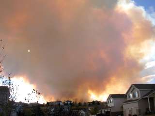 Photo taken about1 hour after seeing smoke. | ||
Sergei Rodionov (Uzbad) Senior Member Username: Uzbad Post Number: 464 Registered: 08-2003 |
Late July, early August you should be ok, thats when crowds starts to dissapear (getting colder at night on higher grounds). Mind the bears though And as Brian said - try to not start a fire. Sigarette butts and things like that. Bring fireextinguisher with you - it may come handy on many occasions, if you still havent got it in your RR. | ||
Felix Gumbiner (Felixthecat) Member Username: Felixthecat Post Number: 105 Registered: 02-2004 |
Anton-- What part of Colorado were you thinking of touring? I'd encourage you to check out South-Central and South-Western Colorado... particularly the San Luis Valley and the areas around Durango and Cortez. It'll be much less crowded in the summer than the Front Range, and in my opinion the wheeling is better. There are some beautiful trails in the Valley of the Gods area. | ||
Anton (Anton_r) Member Username: Anton_r Post Number: 69 Registered: 09-2003 |
Felix, I'm looking at the map right now, where I put up trails from Wells' book, and it's mostly around Marble and near Denver ... I don't think Wells lists many trails around Durango ... he has some trails between Lake City and Telluride ... do you know, where I can get trail maps and descriptions for the part that you are talking about ? | ||
Sean Hanagan (Seanh) Senior Member Username: Seanh Post Number: 259 Registered: 05-2002 |
Anton, Log onto http://www.4x4trails.net/ and search: Old Chinamans gulch, Carnage Canyon, Bill Moore Lake, Spring Creek, Wheeler Lake, Eagle Rock/Saran wrap, Blanca Peak, and Holy Cross. That and the Colorado gazeteer maps and you have yourself a vacation . Those will keep you busy and happy! | ||
Glenn Guinto (Glenn) Senior Member Username: Glenn Post Number: 861 Registered: 02-2002 |
Anton, If you're going to Marble, be sure to check out the the old Power Station...very cool and scenic. There's a fellow named Nick Weede that has a website with GPS logs for the trails we did last fall. I'll see if I can track his website and post it here. Colorado is truely a magnificent state with tons of scenic vistas and cool Mountain Passes. Something that we don't have much here in the east coast. I guess they weren't kidding when they called it God's country! Glenn ***Edit, just found it... click here | ||
Brian Dickens (Bri) Senior Member Username: Bri Post Number: 1041 Registered: 08-2002 |
All of the trails around Ouray, Telluride, Lake City are absolutely amazing. Everything ranging from 3/10 to 10/10. The San Juans are some of the most amazing IMHO. I have some great camp spots for you if you end up there. And some hiking if you like, drop me an email. The trails you mentioned are likely good ones though, you really cannot go wrong. The closer to Denver and I-70, the more active the trail. Can be good, can be bad, depends on your preference. Arg, really didn't mean to attach the picture of the ugly hiker, but now I can't remove it. Sorry.  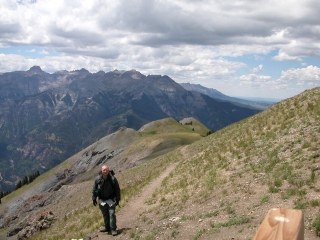  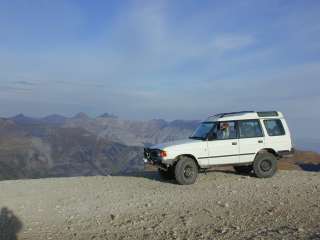 | ||
Anton (Anton_r) Member Username: Anton_r Post Number: 70 Registered: 09-2003 |
Sean, thanks for pointing out good trails, actually most of them I already had marked as preferred on my map, so at least I have good predictability of good trails ;) Glenn, thanks for web-site, I'll check it out Brian, I'm sure going to check out that area of San Juan if you say that it's so good. And I hate wild areas, where there are crowds of people. We are absolutely going to do some hiking - want to get up some 14,000 feeters. | ||
Anton (Anton_r) Member Username: Anton_r Post Number: 71 Registered: 09-2003 |
By the way, I see a lot of small and big lakes there ... are we allowed to swim in them ? I mean, not on mountains - I guess it's pretty cold up there in lakes (though, we swam in some up the mountain - like 10 second swim :D ) ... but anyway, is it ok to swim in them , it's not prohibited or something ? .. with the way everything protected here, I'm afraid to do anything : ) | ||
Brian Dickens (Bri) Senior Member Username: Bri Post Number: 1043 Registered: 08-2002 |
It should be posted where you can swim. All lakes in CO are pretty cold, but refreshing on a hot day. I believe that the only restrictions will apply to lakes/resevoirs that are frequented by crowds. Around Ouray is many excellent day hikes from easy to difficult/logn and short, but so do many places in CO. Uncompahgre is a 14er between Lake City and Ouray that sees relatively little action as far as 14ers go. 14ers, especially those in close proximity of Denver and other Citys are VERY crowded with peak baggers. Sneffles is supposed to be AWESOME and is also in the Ouray/Telluride area. July will be monsoon season so start and finish summit hikes early to avoid Thunderstorms (rain is no problem, lighting at 14k is). If you like books, try Colorados Fourteeners From Hikes to Climbs. Don't be afraid, be adventurous, cautious. It really is pretty hard to do something wrong if you are always alert and use common sense. In the San Juans, the 3/10 trails will have quite a few people, but you have TONS of options. The scenery is the best. Once you start hiking, you will see very few people. I hiked Horsethief from Ouray to Engineer Pass and saw not even one person until I hit the pass. Engineer pass should be in your trails book. Its an easy one, even for stock LR vehicles. The pics above are from Governers Basin/Yankeeboy Basin, Horsethief trail/Bridge of Heaven, Approaching Eng. Pass and Eng. Pass. I typically do Aug/Sep out in the San Juans, but any excuse is a good one for a shorter adventure and I am really wanting to do Uncompahgre again and attempt Sneffles. Cheers, Brian | ||
Felix Gumbiner (Felixthecat) Member Username: Felixthecat Post Number: 106 Registered: 02-2004 |
Blanca Peak is a challenging 14er, and the third highest in Colorado. You're also 10 miles from the Great Sand Dunes Nat'l Monument, which are equally spectacular. By the time you'll be down there Medano Pass trail will be open... some fun and scenic sand wheeling. Blanca Pass road is fun because you drive several miles up Blanca Pass before it turns into the 10/10 trail, and can camp anywhere along the way--potentially using your truck as a base camp and making the summit that day. We started at 4 AM, set up a base camp at 6 AM... didn't end up making the summit because of severe weather, but were able to make it down to the camp at about 9 PM. If you want a shorter day, hike up Blanca Pass to Lake Como and have a picnic and a swim. If you're brave you can try sledding down some of the glaciers that lead into the lake! The scenery is unbelieveable. San Luis Valley/Sangre de Cristo Mtns are my favorite spots in CO. | ||
Anton (Anton_r) Member Username: Anton_r Post Number: 72 Registered: 09-2003 |
Here I made a little plan, to get me started ... do you think this is a good one ? Basically our plan for a day is drive a trail, enjoy surroundings, go to side roads, if there are any, find a good spot to camp Days: 1. RedCone - Webster (my dad really wants to go to RedCone, since he read about it in one of LRW) 2. Italian Creek and/or Taylor Pass and/or Pearl Pass ... I'm most inclined to do Pearl Pass -> Itallian Creek, though, they seem long 3. Old Chinaman's Glutch and start to head down to San Juans 4. Hiking in San Juans 5. Poughkeepsie or/and Black Bear Pass | ||
Brian Dickens (Bri) Senior Member Username: Bri Post Number: 1048 Registered: 08-2002 |
That is a ton of area to cover (IMHO). Certainly doable though. From 3-4 is quite a haul, you might wish to look at some driving times in mapquest.com or zip2.com. If it ends up too much distance and time then hiking in and around Maroon Bells would be excellent and is right near to Taylor/Pearl. I have not pulled a map just yet to have a look, but you might consider switching 2 & 3 if you do so. An of course flexibility might be the key, if you miss a day and relax, all the better! | ||
Sergei Rodionov (Uzbad) Senior Member Username: Uzbad Post Number: 469 Registered: 08-2003 |
Brian its 3.5 hour of more or less calm driving from St. Elmo area to Durango Can be done a tad faster, but not much (285->112->160). Also they could use trails to do shortcut from there to Lake City, then Engineer Pass will take them nearly to 550 and thus to Black Bear Anton, you gonna hike? After 2 days raising from what elevation? Consider bringing oxygen, man Unless your family seriously fit - bring some heart medicine - no-shpa, valocordin or something.. Just to be on safe side. And dont drink too much cofee while you at it | ||
Felix Gumbiner (Felixthecat) Member Username: Felixthecat Post Number: 113 Registered: 02-2004 |
Yeah, don't underestimate the altitude and its effect. I've been out here for a little under 3 years and I still feel it. | ||
Art Vigil (Colorover) Senior Member Username: Colorover Post Number: 259 Registered: 02-2003 |
Beer tastes better up here  Works faster too   | ||
Felix Gumbiner (Felixthecat) Member Username: Felixthecat Post Number: 114 Registered: 02-2004 |
That goes for all of life's little vices... P.S. The best sex I ever had was at altitude. | ||
Sergei Rodionov (Uzbad) Senior Member Username: Uzbad Post Number: 471 Registered: 08-2003 |
Art - you mean down there? Last September at GOX i had bloody keg popping up at Imogene (filled up at 5K in Durango) and spilling beer over me laptop... Felix - arf.. You still young | ||
Felix Gumbiner (Felixthecat) Member Username: Felixthecat Post Number: 116 Registered: 02-2004 |
Forever young... but an old soul... | ||
Art Vigil (Colorover) Senior Member Username: Colorover Post Number: 261 Registered: 02-2003 |
Sergei - I may only live a mile high, but I try to get above 14K' as often as possible. Felix - P.S. me too | ||
Brian Dickens (Bri) Senior Member Username: Bri Post Number: 1060 Registered: 08-2002 |
Sergei, I was trying to stay short and sweet on my reply to avoid complications. There would be no possible way for *me* to get from St Elmo to Durango in 3.5 hours (226 miles) if I am taking in the sights, it'd be more like 5-6. Not to mention Durango is a hell of a long ways out of the way to get out to Black Bear and Poughkipsie. I have driven Denver-Gunnison-LakeCity-EngineerPass-Ouray a dozen or so times. St Elmo to Lake City will be at least 3.5 hours and Lake City to 550 via engineer pass will take about the same. Plus if you do Taylor/Pearl or Italian add another 3-4 hours. So this would be a 10 hour day minimum and if you stop and enjoy some sights, ghost towns, cities, or walks I would say it could easily be 12-15 hours. Thus my comments. If this is the kind of day that Anton whats, he is set. I merely wanted to point out how big of a day that would be and also point out the Maroon Bells, also a very, very beautiful spot is right there where he is. Equally as beautiful as the San Juans, just different. Sure the San Juans are great, but to kill yourself to get out there and have *only* one day hiking and one trail day, it might be better worth the time to stay and explore a single area. Shoot, I have spent months in the San Juans and have not even touched all the trails. Art, let me know if you want some company hiking. If you "run" your 14ers though I won't be good company. Brian | ||
Sergei Rodionov (Uzbad) Senior Member Username: Uzbad Post Number: 472 Registered: 08-2003 |
Brian, i am totally agree with you that its longer with sighting and spotting Just tried to outline way of getting from point A to B, thats all. Didnt really mean to nitpick on you. Art - i am suck at hiking Comes to think about it i havent hiked on any 14rs so far, but i have been in CO only for year and bit. Its kind of sport that i am yet to pick up - it still weird for me to just walk for sake of walking. Then again - i am learning | ||
Art Vigil (Colorover) Senior Member Username: Colorover Post Number: 262 Registered: 02-2003 |
Cool Brian, will do. No running at 14K' for me though. I'll stick to the nice thick air down in Denver for that. Sergei, there's still time. Here's a good link for more info: http://www.hikingincolorado.org/ | ||
Brian Dickens (Bri) Senior Member Username: Bri Post Number: 1068 Registered: 08-2002 |
No problem. I really only wish to point out that there are endless options. If driving is Antons main goal, then he will be fine almost doing anything. If he wishes to take it easy he may need to be flexible. Hiking is my summer hobby. I do it every chance that I can get. You do have to have a pain tolerance for the first mile or two if you are doing 14ers or anything else equivelently steep. I am also looking to do the Colorado Trail segments 5-10 this summer. I hope to attempt it in a single shot. Sergie, an absolute KILLER first 14er would be uncompahgre. A bit long, but pretty easy hike right off the Alpine loop by Nellie creek if my memory serves me. | ||
Sean Hanagan (Seanh) Senior Member Username: Seanh Post Number: 260 Registered: 05-2002 |
Sergie, You don't walk for walkings sake, you walk to ski. One of the best reasons to hike in the spring/summer in Colorado is to get in some turns above treeline. | ||
Anton (Anton_r) Member Username: Anton_r Post Number: 73 Registered: 09-2003 |
yeah, driving is my main goal, since last year my dad damaged a knee in mountains and therefore he still can not do a lot of hiking : ( | ||
Sergei Rodionov (Uzbad) Senior Member Username: Uzbad Post Number: 473 Registered: 08-2003 |
Sean - i dont like mountain skiing Guess thats why. Brian - yeah i been at the head of it last year. Thing is - i am normally going out with my son, and he will be 3 yrs next week. Little guy hates to sit in them carrying rucksacks, so hiking on any distance is like killing yourself. May be this year we will try. However - he can hike from bottom to highest point of trail on Animas Mountain with no problem. Going down is different issue Art - lol, thanks for site Again - i am not saying hiking is bad itself Its just that i grew up in siberian forests, so we just normally been walking to get somewhere, not for just walk's sake itself. Breaking cultural stereotypes taking its time | ||
Brian Dickens (Bri) Senior Member Username: Bri Post Number: 1073 Registered: 08-2002 |
Serg, I've been to the top of some 14ers with a 2 year old that made it to the top under his own power. Believe it or not. Came down on his dads shoulders though most of the time. Can't start training too young I guess. Anton, you're set then! | ||
Sergei Rodionov (Uzbad) Senior Member Username: Uzbad Post Number: 477 Registered: 08-2003 |
Brian oh well i got no excuse then. Damn.. | ||
Brian Dickens (Bri) Senior Member Username: Bri Post Number: 1075 Registered: 08-2002 |
LOL. I know! I was completely amazed by it. My neighbor would not believe it. There is no way he could get is little one to walk more than a few hundred yards or so. I'll give a shout when I am headed out next. Likely memorial day or weekend after. Then the Bluegrass festival. |