| Author |
Message |
    
Andy Cawte (Andyc)
| | Posted on Thursday, January 30, 2003 - 06:11 pm: | 


|
Hi Guys:
I'm thinking of purchasing a GPS unit to use mostly in my Rangie and also on the occasional hike. Don't know too much about the different models and features. I would be glad of any opinions from users as what features to look for or avoid and any other comments you may have.
Thanks for your time,
Andy C
94 RRC |
gp (Garrett)
| | Posted on Thursday, January 30, 2003 - 11:22 pm: |
|
check out the Garmin V if you are looking to use 50/50 (car/hiking). or the Garmin 176 if you are looking to keep it in the car more often. both very good units.
176 has a big ass screen and lots of great features. several of us on this board have them. |
Leslie N. Bright (Leslie)
| | Posted on Friday, January 31, 2003 - 08:20 am: |
|
What's your price range? heh heh......
I won't say anything bad about Magellans, but I have a preference for Garmins. We use survey Trimbles here at work, but they're overkill, and pricey (many thousands of $$$$.... and they're not ideal for recreational use anyway).
Garrett's right about the 176 having a BIG screen.... it's great for a vehicle-install, but I don't think it'd be much fun to hike with.
I've got a Garmin GPSMAP 76S, and love it. It's the one that finally had everything I wanted in one package.... nice screen, enough memory for loading maps into it, built in compass and barometric altimeter, and it has an external antenna input. The smaller Garmin eTrex Vista is pretty similar, but it didn't have the ext. antenna port that I wanted.
I would suggest getting one that has mapping abilities.... Thing about a GPS, a basic one that gives you your lat/long is great, if you know how to put it onto a map... a lot of folks don't know what to do with the coordinates once they have them. If you have a map loaded in there, then it's like it's putting a finger on the map where you are, which helps out a lot.
But, know how to use a map w/o it, though, and just use it as a convenience tool, IMHO....
FWIW...
-L |
Andy Cawte (Andyc)
| | Posted on Friday, January 31, 2003 - 11:32 pm: |
|
Garrett and Leslie:
Thanks for your input, anyone else?
AC |
Eric Pena (Evalp)
| | Posted on Saturday, February 01, 2003 - 12:36 pm: |
|
I agree with the Garmin GPS V. I have the III+ and I love it. The V is the same but it has more memory and can do door to door directions and address finding for car use. It has a smaller screen and is monocrome but it lasts longer on batts.
It runs on 2 'AA' batts and can run with those for like 30 hours or something so it is great on a hike. It can also plug into a power source and external antenna for use in the car.
That is my reccomendation for a GPS, get Garmin and do the III+ or V if you can. |
Jason Lord (Ronan)
New Member
Username: Ronan
Post Number: 62
Registered: 10-2002
| | Posted on Sunday, February 09, 2003 - 11:03 pm: |
|
I recently bought the Garmin eTrex Vista. It is most useful when hiking but connected to the dash mount and lighter adaptor it works well in the truck. Also can be hooked up to the laptop for longer trips. So far, I am very happy with it. It has 24 MB internal memory and runs about $400 Canadian.
Jason |
Andrew Clarke (Aclarke)
advanced member
Username: Aclarke
Post Number: 211
Registered: 10-2002
| | Posted on Monday, February 10, 2003 - 02:44 pm: |
|
Does anybody know whether you can get good maps for Baja California for any of these GPS units? |
Leslie N. Bright (Leslie)
advanced member
Username: Leslie
Post Number: 1746
Registered: 02-2002
| | Posted on Monday, February 10, 2003 - 03:57 pm: |
|
Hmmm......
I'll have to check it tonight when I get home, but, the base-map might go as far down as LaPaz if you get Garmin's MapSource Topo for the US....
Do you want "road", or topo, or what? For the whole penninsula, or just part of the way down?
I'll let you know what I find later tonight....
-L
|
Andrew Clarke (Aclarke)
advanced member
Username: Aclarke
Post Number: 212
Registered: 10-2002
| | Posted on Monday, February 10, 2003 - 04:11 pm: |
|
Well I don't own a GPS but I'm thinking of getting one. I'm planning on driving down to Cabo San Lucas & back later on this month, and since I don't speak Spanish and have never been past Ensenada I'm considering whether or not I should get a GPS.
Are there any opinions on this? I don't have very much $$ right now which makes it hard to justify the expenditure, but it is something I've been thinking of getting for a while, for various reasons.
Thanks,
- Andrew. |
gp (Garrett)
advanced member
Username: Garrett
Post Number: 1804
Registered: 10-2001
| | Posted on Monday, February 10, 2003 - 05:48 pm: |
|
i am sure that the MapSource CD's that Garmin sells would be what you are looking for andrew. i have the topo maps and they work really nice. check out garmins site and look at the software they have. by the way i was in Ensenada years ago......it was fun. driving along the coast and buying 6 packs of sol for mucho cheap.  not at the same time though. not at the same time though. |
Leslie N. Bright (Leslie)
advanced member
Username: Leslie
Post Number: 1747
Registered: 02-2002
| | Posted on Monday, February 10, 2003 - 09:40 pm: |
|
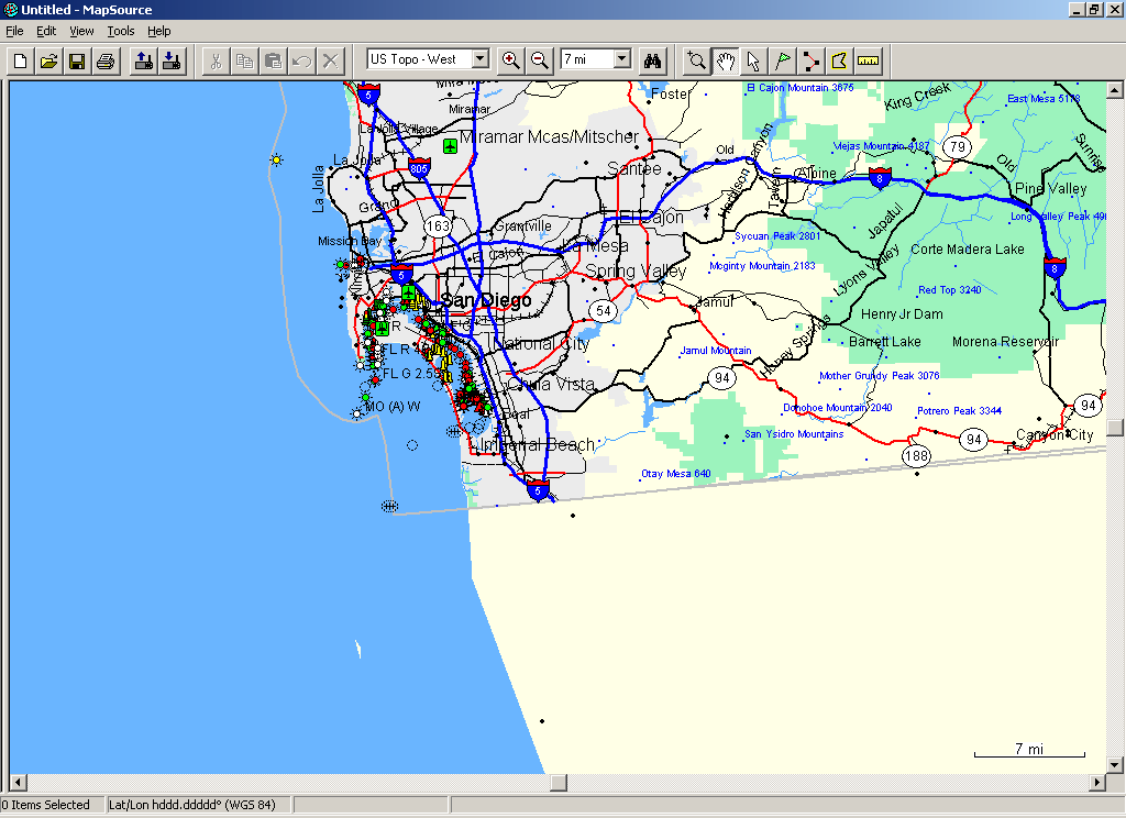
Okey-dok....
The US-version of Garmin's Mapsource Topo cuts off at the border.... while the base-map extends to La Paz, there are only points for towns, no detail.
For example:
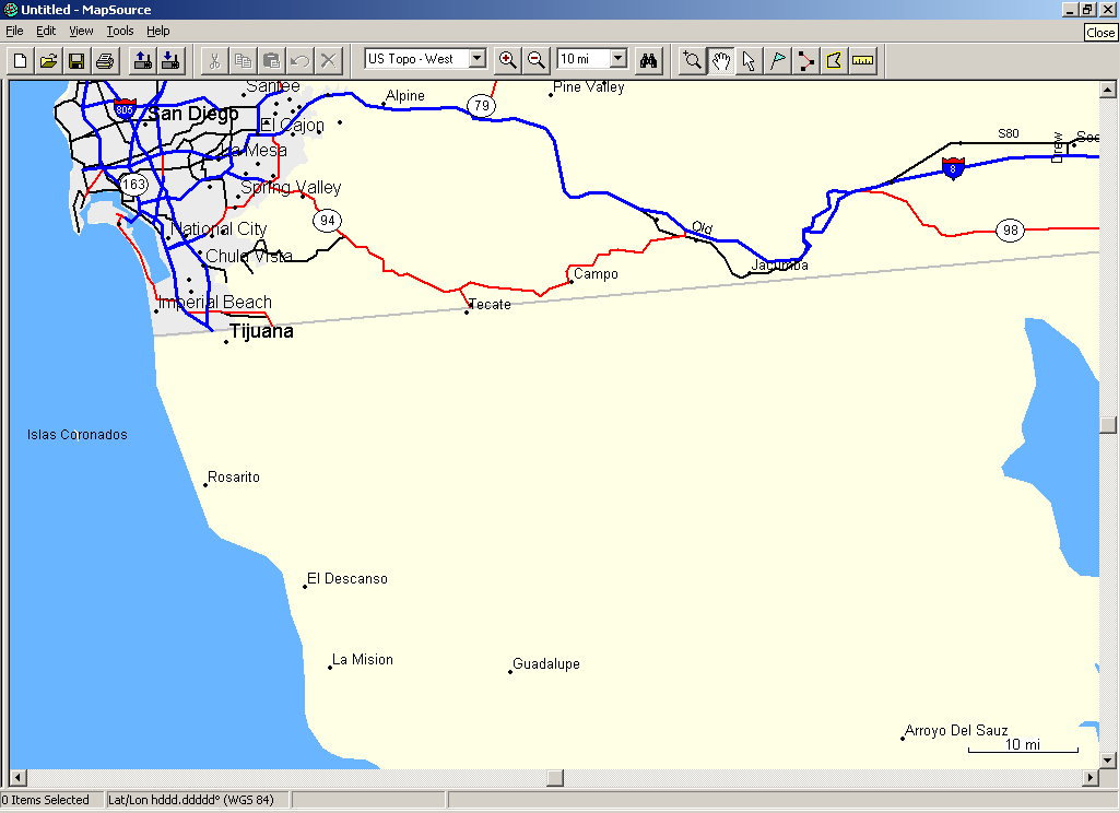
Now, if you zoom in one more step, you can see some more detail coming in, and the labels for points south of the border drop off....
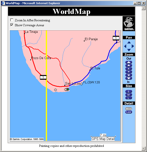
I checked a few of Garmin's other programs, and the only one I found that had more info on Baja was their World Map version of MapSource... it doesn't seem really detailed, but, it'd have the major highways....
Of course, if you have a laptop or a PDA, you can use other software in conjunction with a GPS, and do a lot more....
FWIW.....
-L |
Rich Lee
Unregistered guest
| | Posted on Tuesday, February 11, 2003 - 12:48 am: |
|
Hi Andy,
I was given a Garmin Rino 110 ($169) for Christmas. It is waterproof, compact and has a GMRS/FRS (5 mile/2mile) radio as well. It is light on features, but gives me all I need. If I want/need mapping for Search and Rescue work, I'll hook it up to a laptop (in my case, a 14" ibook running Topo over Virtual PC). It gets pretty good reception clipped to a cheap cell phone mount near the right edge of the instrument binnacle.
I do not yet have much need for in-dash navigation, as I don't like the distraction, and I usually look at a series of maps before I hit the road and rely on my photographic memory.
I like having all of the features of the Rino in 1 unit and I am impressed with the construction/features and durability.
The ideal setup is to have all of your friends/SAR team carry the same setup so you can waypoint each other every time you talk.
If you want something fun to do with your GPS, go "Geocaching" (GPS treasure hunting). Check out www.geocaching.com .
It's also a great way to entice kids to go on a hike/mtnbike ride/off-road drive, because they will actually have fun answering the question, "are we THERE yet?" all by themselves. |
Andrew Clarke (Aclarke)
advanced member
Username: Aclarke
Post Number: 219
Registered: 10-2002
| | Posted on Tuesday, February 11, 2003 - 01:38 am: |
|
Hey Leslie. Wow, thanks for the info! I was actually looking at the same maps at garmin.com and then came back to find you'd done all that.
Yeah, it looks like the worldmap one is the way to go although honestly for this trip it looks like I'll be better off with a plain old map. Since I'm basically just driving south on the only road there is anyways...
My wife is down there right now and she has our laptop so I wouldn't be able to use it with a laptop on the way down anyways. But you're saying I can plug pretty much any GPS into my laptop and use it with pretty much any mapping program? That's good to know.
Thanks again, everybody! |
Leslie N. Bright (Leslie)
advanced member
Username: Leslie
Post Number: 1753
Registered: 02-2002
| | Posted on Tuesday, February 11, 2003 - 08:06 am: |
|
Yep, you pegged it, pretty much any GPS can plug into pretty much any laptop, and then be used with pretty much any program!
Just make sure that the GPS has NMEA out... there'll be some sort of cord that goes from the GPS to a serial port (I've not seen a USB one, but, it wouldn't surprise me if some use them).
Note: mine does fine in the vehicle w/o an external antenna, but, it'd be better to use an external antenna if you have lots of problems dropping tracking... ie, I was scooting along the Blue Ridge Parkway in the Roo, in and out of trees, and it'd lose itself occasionally. Heated windshield wires can cause problems w/ this, so Freelander and DII folks need to be aware of that potential problem...
If you don't want one to hike with, Delorme makes GPS units that have to have a computer to run... they're a little cheaper that way, and you use their software, but, I like their programs anyway. Thing I like about the mapping Garmins, though, is that you can load topos into it and don't have to carry the laptop along....
Anyway, just wear out the Garmin site, and you can learn a lot. Also, check out http://gpsinformation.net/ , it has a lot of good info.....
-L |
|