| Author | Message | ||
joshua Frances (Joshua) Member Username: Joshua Post Number: 120 Registered: 10-2002 |
I got emailed some coordinates of where I bagged my moose this fall, and wanted to try and figure out where it was on a map. short of getting out the actual map, is there a map site I can plug these numbers in. please note i have no experience with gps coordinates, so i dont even know what they mean. anyone wanna de-code or translate what they mean to me? Thanks joshua first one says 46degrees 17.377'N,68 degrees 36.589'w second reads 46 degrees 14.075n,68 degrees 37.784w Thanks! | ||
Jim H. (Victor_mature) New Member Username: Victor_mature Post Number: 15 Registered: 02-2003 |
That puts you up around Chicoutimi, Canada I was using a globe so you'll get a little more accurate with scale maps. Now, the question is, Does the moose have a GPS? The first number is lattitude, the equator is zero, the poles are 90, thus 46 degrees North lattitide. "17.377'" is 17 minutes, 377 seconds. Each degree is comprised of 60 "minutes" (each minute equals 6060 feet). The second number, "68 degrees" is longitude. Greenwich, England is zero (thus Greenwich Mean Time) and 180 degrees out from that is in the middle of the Pacific -the internat'l dateline. 68 degrees west longitude, 36 minutes, 589 seconds puts you in SE Canada. The more detailed the map, the closer you'll see. With coordinates that accurate, you should be able to find the shell casing that you ejected from the gun. JH | ||
joshua Frances (Joshua) Member Username: Joshua Post Number: 121 Registered: 10-2002 |
Jim, thanks for the help are there any sites that can pin point the location by plugging in the coordinates?? anyone? | ||
Mike McUne (Mikem) New Member Username: Mikem Post Number: 10 Registered: 02-2003 |
http://www.topozone.com | ||
Leslie N. Bright (Leslie) Senior Member Username: Leslie Post Number: 1860 Registered: 02-2002 |
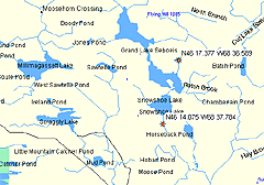
They look to be northeast of Baxter State Park, on Grand Lake Seboeis, in Maine.  -L | ||
Reed Cotton (Reedcotton) New Member Username: Reedcotton Post Number: 36 Registered: 01-2003 |
You don't know where you were when you bagged your moose? -Reed | ||
joshua Frances (Joshua) Member Username: Joshua Post Number: 122 Registered: 10-2002 |
reed, yeh i know where I was...I mean, generally speaking. Northern Maine. But while wandering the paper roads back through there, I found a sweet, untouched lake with a beautiful campsite. I can find it from where I bagged the 700 pounder, but i would have no clue how to get back to the site if i didnt have my buddy log the gps coordinates. I just want to go back and find that camp site, man it was beautiful. and lots of ducks, mwwuhhhhhhhaaaaaa | ||
Eric Pena (Evalp) Senior Member Username: Evalp Post Number: 431 Registered: 06-2002 |
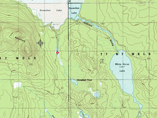
68 36.589'w being a -68 36.589 in data, Leslie is right. It puts you right off of Lost Pond for the first one and the second just South of Snowshoe Lake. Here are some pics. Red 'X' indicates exact location.   If you want, I can email you better versions. |