| Author | Message | ||
R. B. Bailey (Rover50987) Senior Member Username: Rover50987 Post Number: 578 Registered: 07-2002 |
Just got my birthday over with and thanks to my parents and my grandmother I was able to get a new set of tires and a new GPS! I got AVON 215/85 Mud Terrain. Ya the 215 is really thin, but I like it. (Actually, if you think about it, 20mm is not that much thinner, but they look it) And the AVON tires are really nice, I would compare them with a cross between the BFG A/T's and M/T's, but closer to the A/T's. They run really smooth on the freeway. Anyway, the GPS is the Magellan Sportrak Pro from Costco. $289 for the pack with a $15 car adaptor, $15 car mount, $15 carry case with belt clip, and $100 Streets & Destinations Software. The GPS alone would be about $200 at any retail store, and on top of all that you get a $75 rebate. I have already taken it off road into places where there are hundreds of logging roads to get lost on. Having a GPS made a huge difference in being able to simply drive and have fun and navigate at the same time while planning to get back for breakfast before too long. I also picked up the National Geographic TOPO software which gives you the ability to print 7.5+ inch topo maps on waterproof paper. The maps and the interface with the software and the ability to freehand draw routes and waypoints are really worth the money. They are very detailed and highly accurate. They allow you to upload and download track, elevation, and waypoint info to the GPS, but you still have to buy the TOPO from Magellan to get true topo features on the GPS. I will be posting topo maps of my off-road drives on my web site, along with Lat/Long info and waypoint files to download. http://landrover.mrbaileyshistory.net | ||
Brian Dickens (Bri) Senior Member Username: Bri Post Number: 401 Registered: 08-2002 |
What is the scale of the TOPO software? Does it enable you to download to the GPS? | ||
R. B. Bailey (Rover50987) Senior Member Username: Rover50987 Post Number: 579 Registered: 07-2002 |
General Reference, National Atlas, 500k Series, 100k Series, and 7.5' Series. Pluse you can "zoom" in or out between 25%-400%. The resolution stays pretty good on the computer, but prints best in 7.5' or 100k. I have found that while plotting tracks or getting the track off the GPS the N.Geo.TOPO is more accurate than the Magellan Streets and Destinations. But the Magellan program is nice for actually putting it on the GPS and driving around - just cross refference it with the TOPO when going off road. Also!! The N. Geo. Topo does work with live tracking, so you can put it on your lap top and have it with you in the car - it would be the ultimate program for live tracking if you happen to have a nice lap top. It does allow you to download to the GPS, but only track, and waypoint info - but it is very accurate and has good elevation info - but not topo info. Here are the tires I got: 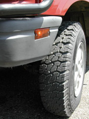 | ||
Peter Matusov (Pmatusov) Senior Member Username: Pmatusov Post Number: 798 Registered: 09-2002 |
R.B., I personally found handheld GPS the MOST dangerous thing to have in the car while driving. I didn't realize that until I drove from Anaheim to Dana Point without knowing it - because I was busy programming my waypoints en route to San Diego (as if I didn't know how far it was or how long would it have taken me to drive there)... peter | ||
Greg Tearne (Gooddoggomez) New Member Username: Gooddoggomez Post Number: 38 Registered: 02-2003 |
I went fishing with a mate on the weekend, 9 miles out to sea and this guy used his hand held GPS (and fish finder) to put us right on top of this reef ("Nine Mile Reef" - go figure). I was amazed, this was my first exposure to GPS and I can tell you, I have become a convert. The fish didn't stand a chance. | ||
Reed Cotton (Reedcotton) Member Username: Reedcotton Post Number: 127 Registered: 01-2003 |
Dana Point to San Diego... What an adventure! Yoiu make a good point though. I learned my lesson in a similar venue. Now I do the programing on my desktop, and if I missed a "valuable" waypoint, I will at least have the atvantage of having looked at the map at least once before the trip. -Reed | ||
R. B. Bailey (Rover50987) Senior Member Username: Rover50987 Post Number: 580 Registered: 07-2002 |
Yes, the GPS is one of the worst things you can have on the road! You have to have it set up and ready to go BEFORE you start driving - it's worse than a hamburger with a side of cell phone. | ||
Greg (Gparrish) Senior Member Username: Gparrish Post Number: 1255 Registered: 04-2002 |
Bailey, No offense what so ever, but are you sure those are mud terrains? I have the Goodyear MTR's which are glorified All Terrains I think, but those look like BFG All terrains to me. Not much open real estate between those lugs. Just an observation. Greg | ||
Ian Kreidich (Ian95rrc) Member Username: Ian95rrc Post Number: 41 Registered: 03-2003 |
I would be careful not to depend on GPS to navigate you too much. Something as simple as your batteries being dead could leave you without GPS. The civilian signal isn't perfectly reliable either. I guess as a pilot I deal with GPS a little more seriously. We aren't allowed to soley rely on it for IFR navigation. I'm just saying it's useful to have but it causes problems when people get complacent about keeping track of where they are on their own. It's definitely a nice toy though. Ditto about the tires Greg. | ||
Reed Cotton (Reedcotton) Member Username: Reedcotton Post Number: 131 Registered: 01-2003 |
Ian- I wouldn't soley rely on it for IFR either. As far as car navigation goes, it could easily be off by a block in the city. And it never tells you if the street is one way (the other direction). But on the dash (firmly mounted), it makes a fun spedometer, and off road it leaves a good trail of breadcrumbs. -Reed | ||
Perrone Ford (Perroneford) Member Username: Perroneford Post Number: 113 Registered: 02-2003 |
Reed, what's wrong with your GPS? And Ian, the FAA is paranoid about everything but they do have a lot at stake. I have run GPS for a long time. I have been exremely pleased with it for the most part. The best two additons I made were #1 connecting a high performance mil antenna to it, and #2, connecting it to good mapping software. I cannot even concieve of being a block off in the city or anywhere else. The addition of WAAS makes this even less likely. On my non-WAAS GPS unit with external antenna, I can almost navigate a wide street blindly. The Delorme software also indicates 1-way streets and other pertinent info. I'd strongly suggest you get a copy. You can pick up a suitable laptop one Ebay for a couple hundred bucks, buy a mobile stand for about the same, and a cable and you're good to go. I had my lighter plug hotwired a long time ago so my GPS unit is always powered up as is my CB. Be safe out there... -P | ||
Greg (Gparrish) Senior Member Username: Gparrish Post Number: 1257 Registered: 04-2002 |
My Garmin 176c seems to be able to hold about 7ft. accuracy for the most part. I have an external Titan Mighty Mouse antenna on the roof rack. It has around 29db of gain. I've seen the accuracy get better, and I've seen it get worse, but for the most part, it holds a pretty steady 7ft. accuracy rating, so I can't imagine being off by a city block either. I think, what is more likely, is finding that the Garmin software may be off by a city block in a few places. It seems like Garmin is still using a map from a few years ago. I saw a new version of my software for sale, Metroguide. I have 4.13, but I think I saw 5 or 5.5 for sale now. Maybe worth an upgrade. | ||
Ian Kreidich (Ian95rrc) Member Username: Ian95rrc Post Number: 42 Registered: 03-2003 |
Actually the FAA would like to save a ton of money and use GPS for sole means navigation and Surveillance. However, the risks are too great at the moment. If you don't believe me read this interesting report on GPS vulnerability. http://www.navcen.uscg.gov/archive/2001/Oct/FinalReport-v4.6.pdf WAAS has alot of problems Perrone. At least as far as aviation use is concerned. It does help though. As far as I know most handheld GPS units do not have RAIM built in. RAIM basically warns a user when a salelite or WAAS goes down. My real point is that GPS makes people lazy so when they loose it they are shit out of luck. | ||
Perrone Ford (Perroneford) Member Username: Perroneford Post Number: 116 Registered: 02-2003 |
Agree with you Ian about getting lazy. I learned to nav with compass and topo. Still keep 7 minute maps in the truck for most of the areas I travel and statewide, paper, Delorme Gazeeteers for my state and neighboring states. I'll have to read that article on GPS later today... -P | ||
Brian Dickens (Bri) Senior Member Username: Bri Post Number: 410 Registered: 08-2002 |
Accuracy depends on if the GPS supports WAAS, if you can get the WAAS and how many satellites fix. I just got the Geko 201 (main reason is for nav and placement onto a topo, not having integrate map on the GPS itself). Since I have have yet to have any problem on roads and 4x4 trails, it is primarily for backcountry hiking. This unit is small and cheap and would be worthless while driving. I am starting to question my decision now since I need to spend yet another $100 on topo software for it. | ||
Perrone Ford (Perroneford) Member Username: Perroneford Post Number: 118 Registered: 02-2003 |
My GPS doesn't support WAAS, but I consider it very accurate. The external antenna means I am pulling 5-8 satellites most of the time which gives very good accuracy. I discovered after going through 2 GPS units that the only way I'd be happy was to connect it to a laptop running vector based software. The GPS units themselves are pretty poor for road navigation. The marine charts and Aviation ones seem to do a far better job. The Jeppesen database enabled ones especially so. -P | ||
Brian Dickens (Bri) Senior Member Username: Bri Post Number: 411 Registered: 08-2002 |
WAAS enabled GPS gets 3m accuracy, the best that I have seen in two uses on the geko is about 8m as I recall. The latest stuff on the market locks up to 12 satellites and WAAS. The problem without software on a lowend system like a Geko is that there is no street or contour map on the GPS. For how I use the GPS (or plan to) one must get waypoint information into it so that you can track a route. To do this with a 4 button non-alphanumeric keypad is a pretty laborious process that involves measuring on your map and entering the lat, long, elev or northing, easting, elev. If I had software it would make entry easier (if needed at all, since many road/trails... are in the TOPO software. But how accurate, certainly not as accurate as a topo that you can buy and you will still need topo backup. At least for the first few trips I will try to enter the coordinates from a map to form the route. I guess it is good practice and will certainly familiarize you with the route. | ||
Reed Cotton (Reedcotton) Member Username: Reedcotton Post Number: 140 Registered: 01-2003 |
Perrone- Actually the GPS is pretty good, and I have gone out and used it occasionally for my primary navigation tool. But... Driving around here, I am usually at the bottom of some tall rewoods, and even with a high gain antenna, the signal can disapear. The other problem is maps. There are places locally, and in other parts of the country where the GPS consistenly reports the road to be many feet away from where my truck is driving. (Bothe DeLorme and Garmin maps, though each has its own errors). Even with some updated Delorme maps they report the road I live on ends a few miles down from my house (It doesn't, and I have reported this to the company.) This makes any of their auto routing programs pretty usless for me to start from home with. Ian is right on. No matter what kind of navigation tool you are using, always have a backup plan, or your adventure might get a bit more tense than you like. -Reed "I'm not lost! I'm just exploring!" | ||
Perrone Ford (Perroneford) Member Username: Perroneford Post Number: 121 Registered: 02-2003 |
Reed, what kind of antenna are you using? Even in the middle of the pine forests here in FL (notorious for killing GPS signal because the pine needles are very similar in length to GPS waves) I lock 5+ satellites. When I first got my antenna, I was in front of my computer in the house, turned on my GPS on batteries and locked 5 satellites inside the house. I lock 6 inside my garage with the door closed, and 3 inside the concrete parking garage at work. If you lose signal in the redwoods, something is way wrong. I too have seen some map inaccuracies as well with Delorme, but rarely does this effect highways, or downtown areas. Since the national forests have had their roads surveyed and reported, I find those to be practically dead accurate. Even the 2-track jeep trails in the forest near my house are dead accurate on the Delorme SA7, SA8, SA2003, and TOPOUUSA 3. -P | ||
R. B. Bailey (Rover50987) Senior Member Username: Rover50987 Post Number: 592 Registered: 07-2002 |
YOU'RE ALL RIGHT. That is why I use the TOPO software too - it allows me to print the map with my projected plan of action on it, then if my GPS explodes, or whatever else could possibly go wrong with it - since I carry extra batteries and have a car adaptor. I can nav out on my own. Yes, I know how to use a compass and a map - I am a pilot. Yes, the WAAS does make a difference, and the new type of antenna they put in these is nice. My old GPS would take about 20 minutes to lock on, then it would loose the signal just before you try to use it. But it was as accurate as could be when locked on. The new one takes no more than 3 minutes, and less than 15 seconds when hot. Again, using a laptop with the National Geographic software would be great. But what about the batteries on the laptop??!! No, they are not MUD TERRAINS like we are used to seeing, that is what they are called though: Avon Mud Terrain SXT. They are pretty much exactly what I was looking for. I didn't want a true mud terrain, but I wanted something more aggressive than most A/T's out there. The Wild Country TXR's were the other option, they look good on Discoverys, but these Avons were put on the shelf at Les Schwab becasue too many people were complaining about the noise of the Wild Country TXR's. Avons are put on LR's in Britain. And they were about $30 cheaper than the BFG A/T's and the tread looks better - I don't know about performance off-road though. Put it this way, When I do go off-road with them I will be amazed, my other tires were so bald that I got a flat from running over a rock, and the other one started coming apart when the guy tried to take it off the rims!! | ||
Reed Cotton (Reedcotton) Member Username: Reedcotton Post Number: 142 Registered: 01-2003 |
Perrone- There you go making me think again. The antenna I have was from some guy down in Florida. Previously I had tried several, and it was the one that gave the mose consistent good performance. Now that I think about it, the places I loose signal are not only at the bottom, to halfway up some very tall trees, but also in a very steep canyon. (Driving up the canyon should explaine the comment about halfway up the trees). So, rock vs redwood? I'm betting on the limestone. Always carry maps, they make great fire starters. -Reed | ||
Perrone Ford (Perroneford) Member Username: Perroneford Post Number: 123 Registered: 02-2003 |
R.B., my laptop is running off the car. I have a power inverter in the truck so I can power several A/C accessories. Generally, it's just the laptop running on it, but when I have to work on the truck, it's the Dewalt battery charger and the 500w shoplight. The laptop draws very little current. I've never used the Natl. Geographic Software. I've always just used the Delorme. I borrowed the Garmin software once, but it was horrible. Reed, I see what you mean about losing signal. I wonder what the gain is on that antenna you have. Of course thost GPS radio waves won't penetrate the redwoods and the limestone, but if your vehicle radio works in that area, your GPS should too. -P | ||
Brian Dickens (Bri) Senior Member Username: Bri Post Number: 418 Registered: 08-2002 |
Fine. That is all I needed to hear about Garmin. How long ago was this? Hey at least REI has satisfaction guaranteed! | ||
Perrone Ford (Perroneford) Member Username: Perroneford Post Number: 127 Registered: 02-2003 |
I borrowed the Garmin software about 2 years ago. Maybe it's better now. I stick with Delorme because it works. Very well. -P | ||
R. B. Bailey (Rover50987) Senior Member Username: Rover50987 Post Number: 597 Registered: 07-2002 |
The magellan software is pretty basic, it works, but it isn't an exact science so-to-speak. The National Geo is much better - just plain high quality. But you need the magellan along with youyr GPS, or the database that comes on the GPS is lacking... | ||
Ian Kreidich (Ian95rrc) Member Username: Ian95rrc Post Number: 43 Registered: 03-2003 |
"Yes, I know how to use a compass and a map - I am a pilot." I had a little laugh at that because other than new privates, most of us kinda suck at dead reckoning. I'm studying for my CFI so I'm brushing up on it. Actually because of GPS, true dead reckoning in the air is sorta becoming a lost art I think. One of the reasons I said people are becoming lazy is I see myself cruising on autopilot, monitoring systems, but not often looking at a paper chart. I think it's especially true in IMC (the clouds) I'm totally dependant on the GPS if I'm busy dealing with a problem. If I loose GPS or other navs, I'll just let center know and let the vectoring begin. As far as using maps on a laptop, I don't think there's anything wrong with that. If I had one I'd run that setup. I'm using a pocket pc at the moment. Your paper map could blow away in the wind. It's all about finding the right amount of acceptable risk in my opinion. Has anyone compared National Geo against Delorme? I have TOPO USA 3.0 and I need to upgrade my setup. At the moment I think I'm just going to upgrade to 4.0. I wish Jeppesen got into the TOPO software business. | ||
Perrone Ford (Perroneford) Member Username: Perroneford Post Number: 128 Registered: 02-2003 |
Let me know how the Topo 4 is if you go that route. In fact, if you do go that route, can you cut me a copy to evaluate, and I'll reciprocate with the SA2003? I'm hoping that Delorme has fixed the Topo4 so that you can actually install the maps to the comptuer instead of HAVING to have the CD in the tray to operate. It's why I tossed out Topo3. Oh, and why don't you get a laptop? You can get a nice IBM or Dell off Ebay for a few hundred bucks? All you need is a 4-10GB HD and 128k or Ram to run the newest stuff. -P | ||
Ian Kreidich (Ian95rrc) Member Username: Ian95rrc Post Number: 44 Registered: 03-2003 |
If I get TOPO USA 4 I'd be glad to cut you a copy. I kinda wonder if the TOPO maps are updated from 3.0 or the software is just reworked. A cheap laptop is just another thing on my "well its only a few hundred bucks" list. A laptop means another pelican as well. Anyways, I'll let you know what I get. | ||
Perrone Ford (Perroneford) Member Username: Perroneford Post Number: 134 Registered: 02-2003 |
Why does a laptop mean another Pelican? I've had three laptops and have never used a case of any kind. And Delorme generally doesn't do a major release unless the maps are updated. I'm basing this on about 8 years of experience with their products. -P | ||
Steve Cooper (Scrover) Senior Member Username: Scrover Post Number: 339 Registered: 09-2002 |
I've been using Topo 4.0 for about a year. It does let you run the data from the hard drive. You just have to manually tell it where the data is the first time, then it doesn't look for the CD any more. Here's my rig: http://www.expeditionexchange.com/stevecooper/B034_31.jpg I love the big screen GPS. I don't know how you guys drive and use the 2" screen at the same time - hats off to ya! As far as batteries, I just use the A/C cord into an inverter to keep the laptop charged. I'm using an Earthmate serial receiver which is sometimes very slow in acquiring, so I'm planning to get the new USB version which is supposed to be faster and more accurate - WAAS enabled. Anybody using that or have any better suggestions? Steve | ||
Perrone Ford (Perroneford) Member Username: Perroneford Post Number: 135 Registered: 02-2003 |
Yea, I have a better suggestion. Get a good, standalone GPS that can take an external antenna. Not to mention the fact it can be used without the laptop. While having the laptop is great, there are times when I just don't want it open. In those cases, having a nice screen to look at on a standalone GPS is terrific. I also use mine as an accurate speedo so it's nice to have something on the dash to watch. I'd suggest the GPS 176 if you've got the dough, or maybe the GPSV if not. -P | ||
Rob Davison (Nosivad_bor) Senior Member Username: Nosivad_bor Post Number: 467 Registered: 02-2003 |
yeah, i agree with master p with all of his points plus i have one more. what if you are way out in the desert and the car breaks down. you dont know where you are going, etc. yes you should have a map and all that shit or you can just unstrap the GPS off the dash (if you have a say Garmin 176 with batteries in it) and stroll on down the road with no effort. i guess you could walk home staring at the laptop and holding the earthmate thing but man you'd look like a hardcore geek and you'd just be asking to get an ass kicking from some 15 year old kids. rd | ||
Steve Cooper (Scrover) Senior Member Username: Scrover Post Number: 340 Registered: 09-2002 |
"what if you are way out in the desert and the car breaks down. you don't know where you are going, etc." I'd whip out the Iridium and call AAA  But, yes I agree with portability factor. I often don't take the laptop 'cause I can't be bothered. I'll check those out and the marine antennas. | ||
Rob Davison (Nosivad_bor) Senior Member Username: Nosivad_bor Post Number: 469 Registered: 02-2003 |
found a nice Marine antenna on ebay , seller by the name of GPSGEEK best price that i could find new. they are in your neck of the woods too.. i dont like the little puck antenna because they are goofy to mount, but are less than half the price. 65 for marine and 25 for little puck type from gpsgeek. i talked to the tech guy on the phone and he was on the ball and new his shit. rd | ||
Erik Olson (Jon) Senior Member Username: Jon Post Number: 387 Registered: 02-2002 |
I agree with Perrone on the Delorme observations. I used Topo4 on a PII 14" TFT IBM Thinkpad (POS) exclusively for last years Trans-American Trek both on and off-road with great results. Only complaint was the lack of the USB power cable on my receiver - lots of batteries on that trip. I've since scored the serial power adaptor. My Magellan GPS Companion on a dedicated Visor is much faster at both warm and cold acquisition, but the Delorme is more accurate +/- 10' in my exprience. Also, the foliage-block aspect of the Delorme receiver is excellent, usually picking six satellites even through dense cover. We programmed the return (on-road) from Alberta to California using the Topo4 automap feature - and once you get that hilarious straight-line default removed it is very useful for street-level routing. At one point, we were on a fifteen-mile stretch of graded logging road, but Topo4 definitely chose the quickest route in that situation. On another note, Perrone is also dead-on regarding the balance of reliance on a GPS system and good skills with a compass and a Gazetteer or other minutes-based map. If you haven't already, go buy your own state's map to polish your skills here. I found that, especially with a second person to act as navigator, the printed minute maps and a GPS reading (but not map scrolling) of lat and long was very accurate and quite fast. Has anyone sourced GPS compatible maps for international work? Delorme doesn't have, or intend to produce them. e | ||
Steve Cooper (Scrover) Senior Member Username: Scrover Post Number: 341 Registered: 09-2002 |
Rob, you had to tell me about GPSGEEK dammit. That guy has everything. Now I'll HAVE to get that shit | ||
Rob Davison (Nosivad_bor) Senior Member Username: Nosivad_bor Post Number: 471 Registered: 02-2003 |
fugawi has maps of canada, don't know about the rest of the world. steve, they tell me they are comming out with a black marine antenna soon, so maybe you should wait and get that one. they advised me not to paint mine. rd | ||
Steve Cooper (Scrover) Senior Member Username: Scrover Post Number: 342 Registered: 09-2002 |
"they tell me they are coming out with a black marine antenna soon" That'll probably be a little bigger though... | ||
Robbie Donaldson (Robbie) Senior Member Username: Robbie Post Number: 382 Registered: 02-2002 |
"That'll probably be a little bigger though..." Hahahahahah!!!! | ||
Rob Davison (Nosivad_bor) Senior Member Username: Nosivad_bor Post Number: 473 Registered: 02-2003 |
just in diameter, but not quite as ridgid... lol rd | ||
Perrone Ford (Perroneford) Member Username: Perroneford Post Number: 136 Registered: 02-2003 |
Why the heck do you need a marine antenna? Just get a "might mouse" or one of the Garmin units and you're all set. The marine units aren't any better, and theyr'e a lot bigger. -P | ||
Steve Cooper (Scrover) Senior Member Username: Scrover Post Number: 343 Registered: 09-2002 |
Actually P, I thought I remembered you mentioning your marine antenna, but after re-reading it was a mil. antenna that you spoke of. Which one do you use? | ||
Perrone Ford (Perroneford) Member Username: Perroneford Post Number: 137 Registered: 02-2003 |
Umm.. my mil antenna isn't really available for sale. Perhaps if you know an Army Ranger, he may be able to "procure" one for you. It's the one they use on their pack. Made by Micro-Pulse, under contract to Rockwell. Just get the mighty-mouse. It's a far simpler and cheaper solution that works almost as well. Or if you REALLY want to toss away $500 or so, Micro-Pulse may be convinced to sell you one. That was the price I got the last time I asked about getting a second unit. -P | ||
Steve Cooper (Scrover) Senior Member Username: Scrover Post Number: 344 Registered: 09-2002 |
I'm not ready for this on my truck: http://www.ngs.noaa.gov/ANTCAL/Models/Images/MPL_WAAS.s.jpg I'll stick with the mighty-mouse | ||
Mike Allers (Gfy) New Member Username: Gfy Post Number: 16 Registered: 07-2002 |
Good call Steve...I think you would have alot more questions to answer with that thing on your rover... | ||
Rob Davison (Nosivad_bor) Senior Member Username: Nosivad_bor Post Number: 474 Registered: 02-2003 |
as i stated above: "I dont like the little puck antenna because they are goofy to mount, but are less than half the price." well how would you mount the mighty mouse perrone? do i glue it to the windsheild? gay do i use a stick um plate or screw into my roof? gay do i bolt it to my roof rack floor so i can knock it odd wile i am hauling drywall? gay Do i bolt it under my rack flooring? flaming gay or did putchase a marine style antenna that has a convenient screew shaft that allows me to easly mount it up and out of harms way and get a higher gain antenna then the mighty mouse? | ||
Steve Cooper (Scrover) Senior Member Username: Scrover Post Number: 349 Registered: 09-2002 |
You guys are confusing me now. So, is a Marine's antenna bigger than an Army Ranger's, or is it just the black ones that are bigger? If so, what's the best way to mount it? And what's Rob's obsession with hauling drywall? I need some coffee. | ||
Perrone Ford (Perroneford) Member Username: Perroneford Post Number: 138 Registered: 02-2003 |
Steve, My GPS antenna has a very strong magnetic mount. I place it on the hood, just in front of the driver position. I drop the cable through the gap in the hood, route it inside the truck and onto the back of the GPS. Makes a very nice, clean install. The unit itself is about 3.5" in diameter and about 1.5" high. I guess I'm just not all that worried about people thinking I'm gay. Good luck with your install. -P | ||
Steve Cooper (Scrover) Senior Member Username: Scrover Post Number: 350 Registered: 09-2002 |
Thanks P, I'll get to the bottom of this. | ||
Rob Davison (Nosivad_bor) Senior Member Username: Nosivad_bor Post Number: 475 Registered: 02-2003 |
with all this talk of mounting marines, i'm starting to thing steve is well, you know those british tend to be dandies.. i can see how on the hood would be acceptable but it just leaves a bad taste in my mouth. besides too late now i already have the marine antenna. suddenly i am having visions of colon powell , tommy franks and stormin' norman statuets bolted to my rack with wires coming out of there ass and into my garmin. oh and steve, i dont just haul drywall.. i also hang it. i must say it's not very well hung  christ i'm, starting to make myself sick... rd | ||
Steve Cooper (Scrover) Senior Member Username: Scrover Post Number: 351 Registered: 09-2002 |
"you know those british tend to be dandies.. " yeah, Mike Tyson used to think that too | ||
Ian Kreidich (Ian95rrc) Member Username: Ian95rrc Post Number: 48 Registered: 03-2003 |
It has been awhile since I could get back to this subject. I bought TOPO USA 4.0 and Delorme XMAP street atlas so I could use it with my pocket PC. I was in the Blackhills National Park last week looking for trails and found a few issues with my setup. First, a quarter of the time TOPO USA doesn't agree with the paper 7.5 USGS maps I have. Not a really big deal but it means more work for me. Alot of the time they show a "road" where this is a trail and a trail where there is a road. I found some issues with using the maps on the pocket pc, but I think those are addressed in a patch I hadn't downloaded. My old Garmin 12 worked fine with the software. Overall I found the setup to be good and useful, but it made me wish I had a laptop. The pocket pc is ok but the small screen gets annoying fast. | ||
Perrone Ford (Perroneford) Member Username: Perroneford Post Number: 163 Registered: 02-2003 |
Quote from me, Jun 5: "I discovered after going through 2 GPS units that the only way I'd be happy was to connect it to a laptop running vector based software. The GPS units themselves are pretty poor for road navigation." I use StreetAtlas 8, and StreetAtlas 2003 and find them to be more accurate (particularly SA8) for the road-is-a-road stuff. -P | ||
Greg (Gparrish) Senior Member Username: Gparrish Post Number: 1271 Registered: 04-2002 |
I ordered a ring clamp mount from Kyle at Rover Solutions, and mounted the metal mount plate that came with my Titian III antenna (same as mighty mouse) to the bracket that Kyle made me. I have mine clamped above the driver door, facing inward, but you could put it most anywhere. I have had mine up there for about 3 or 4 months, and other than some rust on the ring clamp, I have had no problems with it. I think mine is rated at 28 or 29 db of gain. I think the garmin marine antenna is only rated at 19db of gain, and the garmin puck is rated at around 13db of gain. Mighty Mouse or Titian III is the way to go for the rover, based on price to performance gain. | ||
Joshua (Joshua) Senior Member Username: Joshua Post Number: 311 Registered: 10-2002 |
do you guys have some pictures of your mounts ( other than Garrets idea of drilling into the dash) There was a thread on it a while back, with some killer pics of different mounts, but i searched and searched and couldnt find it. Looking at mounts for similar units to th egarmin streetpilot and 176c Thanks JOsh | ||
Greg (Gparrish) Senior Member Username: Gparrish Post Number: 1272 Registered: 04-2002 |
Joshua, Mounts for GPS unit, or the antenna? I think I have some pictures at home of both, but I'll have to look tonight and get back to you. | ||
Joshua (Joshua) Senior Member Username: Joshua Post Number: 313 Registered: 10-2002 |
greg I was thinking of the GPS itself. The bean bag looks like a crappy idea, and i hate the idea of drilling into the dash There was a thread a few months back that had a TON of mounting ideas, i just cant find the darn thing josh | ||
Greg (Gparrish) Senior Member Username: Gparrish Post Number: 1273 Registered: 04-2002 |
Yeah, and I forgot to look for it last night. Sorry. I know there should be some pictures of my 176c mounted on a RAM mount floating around somewhere on D-web. I'm not sure what the thread was though. I will try to remember to look this weekend for the pics. | ||
Joshua (Joshua) Senior Member Username: Joshua Post Number: 317 Registered: 10-2002 |
greg Yeh, I think thats what I may remember. any pics you got, will be a big help josh | ||
Greg (Gparrish) Senior Member Username: Gparrish Post Number: 1274 Registered: 04-2002 |
Josh, I emailed you the full size version, but here is the little one that will fit on dweb........ 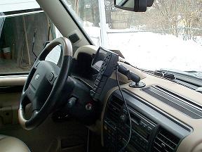 |