| Author | Message | ||
Justin Sherfy (Jrsherfy) Member Username: Jrsherfy Post Number: 44 Registered: 08-2003 |
I'd like to get GPS in my Disco? What brand do you guys/gals use/prefer? JRS | ||
Lance Doyle (Discokayaker) New Member Username: Discokayaker Post Number: 16 Registered: 11-2003 |
You'll get some varied responses from others with much more experience then me. That said, I just received a Garmin V for Christmas and love it. For me it is a good compromise between a dedicated in-vehicle unit and a handheld. . . big enough screen for the truck but small enough to take with me on foot. BTW, hardwire whatever unit you get as it's the only way to go in my opinion. Lance | ||
Jeffery Joel Smith (Wolfman) New Member Username: Wolfman Post Number: 13 Registered: 09-2003 |
I use an old Garmin 12XL interfaced with my laptop and Topo! software. Works great and Topo! uses USGS maps that are purcahsed in regions or state by state. I don't have external antenna for GPS but find the dashboard is fine for the GPS in most conditions. In my other 4X4 I use a cell phone holder for the GPS to keep it from bouncing around. Tree cover still is an issue though. One of the cool features in Topo! is that you can associate pictures (digital) with trail points. Its like a "virtual trail map" of where you've been. | ||
Ho Chung (Thediscoho) Moderator Username: Thediscoho Post Number: 523 Registered: 02-2002 |
for stand alone GPS... i like the 176C. for laptop assisted GPS... earthmate... if i ever get the damn earthmate, i'll let you know how nicely it works. Ho Chung | ||
DW (Dcw) New Member Username: Dcw Post Number: 16 Registered: 01-2004 |
My brother came to hunt for a few days this year and brought his Garmin Rhinos with him. Now we did spend most of our time hunting and the units had two different versions of firmware on them, so we didn�t really spend too much time messing with them, but� They do look cool, GPS plus a two way radio. You can set up contacts, another Rhino, see their location, travel route and much more. A GPS on steroids. | ||
Jamil Abbasy (Jamooche) Senior Member Username: Jamooche Post Number: 295 Registered: 05-2003 |
I use a Garmin GPS V with my laptop and love it. Works great without the laptop too. | ||
Clif Ashley (Cta586) Senior Member Username: Cta586 Post Number: 491 Registered: 04-2002 |
Love my Garmin V. Happen to be based here in KC too. | ||
Leslie N. Bright (Leslie) Dweb Lounge Member Username: Leslie Post Number: 2911 Registered: 02-2002 |
I use survey-grade Trimbles at work, but, they're not best for general use. The GPS that came out that had everything I wanted in one unit is Garmin's GPSMAP 76S. Their 176 that Ho mentioned is better because of the larger screen if you're thinking of a dedicated vehicle unit, but if you want to also grab it and go hiking, the 76S is more suited to being carried along. But, the V and all the other others will be as accurate for your use (the only reason to use a Trimble is if you need to do post-processing to improve accuracy against a base-station). The Rino would be cool in that you can see where everyone else is, but, since I already had both my GPS and my FRS before it came out, I wasn't gonna run out and get them instead. FWIW.... -L | ||
Justin Sherfy (Jrsherfy) Member Username: Jrsherfy Post Number: 45 Registered: 08-2003 |
Thanks for the good posts. I'll check out all of the suggestions. JRS | ||
Adam Ross (Discodriveradam) Member Username: Discodriveradam Post Number: 164 Registered: 01-2003 |
Magellan dammit! (Meridian Platinum, by the way) | ||
Craig Kobayashi (Koby) Dweb Lounge Member Username: Koby Post Number: 962 Registered: 02-2002 |
Garmin 176C | ||
Rob Davison (Nosivad_bor) Dweb Lounge Member Username: Nosivad_bor Post Number: 1524 Registered: 02-2003 |
i agreee 176 is "the shit" http://www.discoweb.org/robdavison/misc/ho020.jpg http://www.discoweb.org/robdavison/misc/ho021.jpg http://www.discoweb.org/robdavison/misc/ho022.jpg | ||
Brian Baker (Doubleb) Member Username: Doubleb Post Number: 64 Registered: 02-2002 |
Leslie, Are you a Land Surveyor. If so what state? I personally love Trimble and wish they made civilian gps models. Currently our company uses leica and I'm not impressed. | ||
Ho Chung (Thediscoho) Moderator Username: Thediscoho Post Number: 526 Registered: 02-2002 |
rob, what happened to your clock? Ho Chung | ||
Leslie N. Bright (Leslie) Dweb Lounge Member Username: Leslie Post Number: 2917 Registered: 02-2002 |
I'm a geologist; I work for VA, http://www.dmme.virginia.gov/ , but live in TN on the TN-VA line. I've had surveying, and make *lots* of maps, but I'm not licensed as a surveyor. I deal with coal mine reclamation, a lot of my work involves old mines, trying to place them in our database so that we can avoid Quecreek-like events here..... We've got a base-station set up here at the building, so we can bring our data back and correct it against our fixed point. Works quite well.... The downside to Trimbles, though, at least as far as the ones we have, is the lack of map database to load into the field unit. I can bring back my points and throw 'em onto a digital 7.5-min topo w/o thinking about it, but I can't have a digital topo in the unit while I'm on-site, unlike my Garmin. (We've got a couple of XLs and several GeoExplorer III's) The newer ones, though, that use ArcPad, (GeoExplorer CE) are sweet.... they're running WinCE, so you can do all the fun stuff with them in the field. However, at $3500 a piece, give or take, it's just not what anyone needs just for be-bopping off through the woods..... Leica: they should've stuck to optics, is all I can say....  -L | ||
Leslie N. Bright (Leslie) Dweb Lounge Member Username: Leslie Post Number: 2918 Registered: 02-2002 |
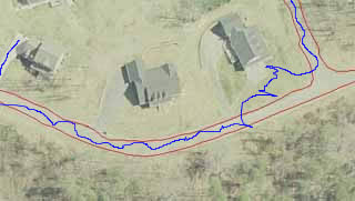
Here's a quick example: Back in the summer, I took a GeoExplorer III, and set it recording while I walked along the edges of the roads in the subdivision where I'm going to build. Last month, we rec'd some new rectified aerial digital photography work, and so I opened up the pic of the neighborhood, then opened up the shapefile of the linework: 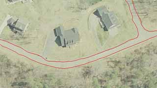 Those lines *aren't* tracing the image, they're out of the GPS, post-processed, then exported into a shapefile. Not bad, eh? -L | ||
Leslie N. Bright (Leslie) Dweb Lounge Member Username: Leslie Post Number: 2919 Registered: 02-2002 |
If you notice: There's a crooked spot in one of the lines: look carefully, and you can see the brick mailbox post that I had to step around, which made the line go crooked.... it's at the end of the driveway of the middle house in the image..... FWIW.... -L | ||
Brian Baker (Doubleb) Member Username: Doubleb Post Number: 66 Registered: 02-2002 |
We, along with land surveying, do a ton of orchard mapping (sub 1m gps ) and detail topography (rtk gps 1cm) using the same principles as your road outline. Ortho photos under that detail really wow the clients. We runout lines and point data, for sub meter area calculations,in a similiar fashion on a quad runner. we fabricated an antennae and controller mount for it and it works pretty slick. It comes in handy when your mapping 140+ miles of shoreline along the columbia river. | ||
Brian Baker (Doubleb) Member Username: Doubleb Post Number: 67 Registered: 02-2002 |
We do most of the line work and image background stuff in Land Development Desktop although our GIS department uses ArcView (ESRI) they each have there place. And yes leica should stayed with Optics. We call our totalstation "the boats anchor" because it weighs about 22lbs. they seem to be about one to two years behind other manufactures | ||
Leslie N. Bright (Leslie) Dweb Lounge Member Username: Leslie Post Number: 2923 Registered: 02-2002 |
I use both..... We've Land Desktop '04 and Land Enabled Map '04 and Raster Design '04, still getting used to the '04 over the previous. Not really different, but there's some subtlety there... We've got a limited number of seats onto Arc/Info and ArcGis.... everyone in the office has the older ArcView 3.2a, though.... I constantly wear it out. I need to start using 8.3/8.4, though, we'll have to migrate to it soon enough.... I don't quite have the hang of ArcCatalog, just because I've not jumped in and really started *using* it a lot... only a couple of demo sessions as of yet. We have a couple of TDS, but I don't ever use 'em... if something *really* needs to be surveyed, like for a construction project, we'll hand it to one of our engineers instead. I'm usually marking old portals, water wells, landslides, etc. etc. GPS is good enough for my needs...... -L | ||
Sean Roche (Crazy_fish) New Member Username: Crazy_fish Post Number: 20 Registered: 10-2003 |
Oddball thought- Sort of 1984/Brazilish Since everycar is going to have one soon, wouldn't it be funny if they used it against you in a drunk driving case? "Exhibit A your honor" Sean's GPS route of 01/27/04 Judge " Damn look at those squiggly lines" Me " Umm there were dogs and squirrls and little girls and pot holes..." Judge " 30 days and $50,000 fine" | ||
Leslie N. Bright (Leslie) Dweb Lounge Member Username: Leslie Post Number: 2925 Registered: 02-2002 |
That's why you drive something older and leave the thing turned off 'til you're in the woods..... -L | ||
Sean Roche (Crazy_fish) New Member Username: Crazy_fish Post Number: 21 Registered: 10-2003 |
 | ||
Leslie N. Bright (Leslie) Dweb Lounge Member Username: Leslie Post Number: 2926 Registered: 02-2002 |
That'd be funny, just driving around the block (the only way out of the neighborhood is the way off to the right, and it'd kill you if you were drunk.....). -L | ||
Brian Baker (Doubleb) Member Username: Doubleb Post Number: 68 Registered: 02-2002 |
Just think if they had pulled the gps log on the EXXON VALDEZ. I bit it would of looked something like that blue line. If he was actually steering that boat all the way down the pacific coast. | ||
Jaime (Blueboy) Senior Member Username: Blueboy Post Number: 873 Registered: 02-2002 |
perfect thread as I'm trying to figure this out myself. I also really like the G176C, yet, was thinking of an alternative route: 1. get a iPAQ 5550 with the same screen size as a 176C and has Bluetooth wireless plus tons of storage 2. get the Earthmate that also is wireless for GPS capability 3. use Delorme maping made for PDAs for the US so far ok as this will work. My question is if I load digital maps like say on Mexico from my PC onto the iPAQ, what will I get?? basically will I be able to track my position on the loaded map? be kind as I have no clue here on this shit. so would it work?? Jaime | ||
Adam Ross (Discodriveradam) Member Username: Discodriveradam Post Number: 165 Registered: 01-2003 |
Dude, I really like my Magellan. I wasn't just kidding with you guys. Granted, it's my first and only GPS, but I don't see how handheld, civilian units can get any better. | ||
Matt Milbrandt (95discovery) Dweb Lounge Member Username: 95discovery Post Number: 188 Registered: 02-2002 |
I have been using the 176 for the past year and a half and been very happy with it. http://www.mistymountainrover.com/GPS_176C Matt | ||
Jaime Crusellas (Jaime) Member Username: Jaime Post Number: 215 Registered: 05-2003 |
I have the Magellan Sportrak pro. Its my first GPS. I like its size, its ideal for off vehicle use, and you can download Magellan's topo map into it. (not the whole thing, but at least a state or 2 and have memory left over). I've used it in the Pine Barrens, and for the most part it showed the same trails that Delorme topo showed. The screen is backlit and has 2 brightness levels, so if you buy the cig adapter, you can keep it on all the time. However, the screen is small compared to the vehicle only Garmins, and obviously to a laptop. But I solved that problem. I recently bought a welder, and ny first project was a laptop mount. I hooked the Magellan to the laptop runnning Delorme Topo, and I'm very happy with the results. So I feel I have a good solution both in and out of the truck. | ||
Leslie N. Bright (Leslie) Dweb Lounge Member Username: Leslie Post Number: 2928 Registered: 02-2002 |
Jaime, Sure. That'll work fine. Plus, your devices are useful for other things. Downsides: The Earthmate isn't a stand-alone product, so it would be somewhat inconvenient to drag it along out of the vehicle if you wanted to go hiking or something. The 176C, even thought it's bigger and more suited to a vehicle than my 76S, is still more easily pulled out and taken on a hike than the Earthmate. DeLorme, Garmin, Magellan, the base files for all of them are rebuilds of Tiger data lain on a coarse-contour topo. The data from one to the next *should* be almost identical, varying based on the build-date of the software's dataset. The laptop will obviously give you the most screen and a more powerful program on the go: but you have to have a laptop along. Not a problem for strictly vehicle-based use. The PDA can make use of Delorme's software, which I like for casual uses. A Garmin or a Magellan have to use their own software (however, there are some hacks out there to let you create your own maps and load them into you Garmin.... kinda neat, something I've wanted to dabble in but haven't gotten around to it yet, other irons in the fire ahead of that....). I'm more partial to, regardless of a laptop or a PDA being involved, the idea of having a stand-alone GPS being used as the receiver instead of a computer-dependent one; mostly as a redundancy / backup idea, but also just to more easily facilitate grabbing it and charging into the brush. (If I'm doing a longer overnight hiking trip, I don't want to carry both the GPS and the PDA along, just the GPS sounds better to me.... ) Adam, Magellan units are comparable, they're okay. I've got holdover issues because early ones I played with were flaky compared to the Trimbles and Garmins I've used..... Eagles were okay too, but, they just had nothing that made me want them over a Garmin. FWIW...... -L | ||
Adam Ross (Discodriveradam) Member Username: Discodriveradam Post Number: 166 Registered: 01-2003 |
Leslie, 10-4. | ||
Victor (Vabiro) Member Username: Vabiro Post Number: 177 Registered: 10-2003 |
Leslie, What do you think of things like the Navman for the iPaq (http://www.fugawi.com/docs/hardframe.html)? I have been using the Fugawi software for a while with my notebook and my iPaq. I don't have a lot of experience, but the Navman seems to address your requirements for portability, high resolution screen and a pretty versitile choice for it's ability to use maps of all kinds. Victor | ||
Leslie N. Bright (Leslie) Dweb Lounge Member Username: Leslie Post Number: 2931 Registered: 02-2002 |
Victor, I've no hands-on experience with iPaqs or with Fugawi. However, friends who have like both. Fugawi is a respected package in some circles. Ipaq is a bit more robust that the Palms of yesterday. There IS something to be said about the additional flexibility that comes when using a separate computing/display device for mapwork. I would find the dependency on a slot-GPS a bit uneasy. If you don't have a problem with carrying a couple of devices, then it's not a problem. -L | ||
Jaime Crusellas (Jaime) Member Username: Jaime Post Number: 217 Registered: 05-2003 |
Leslie, I wasn't sure if I got it accross, but, I use the Magellan handheld standalone outside of the truck, and use it as a GPS receiver (NMEA) connected to the laptop running DeLorme topo in the truck. I don't have the DeLorme earthmate receiver. | ||
Jaime (Blueboy) Senior Member Username: Blueboy Post Number: 875 Registered: 02-2002 |
Leslie, Thank you very much for the information. We're planning a trip to Belize this Summer on our own and most mapping software like Delorme is US based. Hence the idea to download digital maps of Mexico into a PDA and use it to position where we are. Cool thing about the new Earthmate is it uses Bluetooth wireless technology and now has its own power pack. You could put the Earthmate onto a backback and read the PDA as you move without any wire connection. Samething if the Earthmate is on the Rover. You can recieve signals up to about 10 meters away out of the Rover. Plus I need a PDA! SO just to confirm, I can load some decent detailed digital based maps into the PDA and figure out where I am! Thx again Leslie. Jaime | ||
Leslie N. Bright (Leslie) Dweb Lounge Member Username: Leslie Post Number: 2948 Registered: 02-2002 |
Jaime C, I was replying to Jaime Blueboy, no confusion there.... Jaime, Yep, that should be fine. The fact it can go wireless is cool, that'd be kinda nifty. If you need a PDA anyway, then you might as well put it to use. If you haven't done it, I'd suggest wearing out the website, get an idea what the mapwork is like. I have no idea what kind of detail they'd have for areas out of the lower 48.... you would have the *capability*, but I don't know about the *availability*. Now, I suppose I should throw out one more caveat: I don't have hands-on on the iPaq... my understanding is, it's almost more like a palm-top PC instead of a Palm-like PDA, as far as its capabilities go. I'm going on the assumption that you would get, at a minimum, the equivelent of what I have in my Garmin, but in color, which would be sweet in-and-of itself. If the program is more robust, though, then all the better. Go see if you can play with the software at some store, on the kind of PDA you want.... some place like Circuit City or Best Buy or wherever... tell 'em you need to see X program on Y machine so you can see how it works... a good shop should be capable of demoing such for ya.... http://www.delorme.com/earthmate/bluetooth.asp Start here, see what you think...... -L | ||
Jaime (Blueboy) Senior Member Username: Blueboy Post Number: 877 Registered: 02-2002 |
Thanks again Leslie. That is the Delorme site I've been scoping. I'm going to be driving right by it on the way back from ECR so will probably stop in and pick their brains as well. It is a very cool store with the huge globe rotating. Yeah, the upper end iPAQ have tons of memory, same screen size as the 176C, and of course in color. Again, appreciate the insight. So you actually advance past the Series electronics in knowledge!  Jaime  | ||
Leslie N. Bright (Leslie) Dweb Lounge Member Username: Leslie Post Number: 2949 Registered: 02-2002 |
lol..... Awhile back, someone was talking about building a PC in the console of their Disco. Well, I started thinking, what if I did that, but in a Series? Actually have a P4-setup running in a 30-some-year-old vehicle..... lol!!! Scary, eh? David tried REALLY hard to talk me out of it. I put it on the backburner, but, I'm still contemplating...... Not anytime soon, it'd be at some point WAY down the road before I even go there, if ever..... The biggest hitch to your plan as far as I can tell, will be finding map coverage for Belize in a usable format. It may very well be that you end up running some other program instead of DeLorme to get it running. I did notice that you can use the StreetAtlasHandheld, and then feed TopoUSA files in through it. If you could find other country coverages, then you'd be set there.... I'll poke around and see if I can stumble across such, but, I'm not sure where.... -L PS: I used to build PCs for fun, and cram multiple O/S's onto 'em.... NT, 95, Dos, Linux, etc.... I'd run Unix reflection seismology software in a Unix emulator running on a PC; and then when i was running the geology computer lab, for the Mac folks I had to get the Unix emulator running inside their PC emulator.... SHEESH! And, I'm just a dabbler compared to a lot of the folks around here on the board... FWIW.... -L | ||
Leslie N. Bright (Leslie) Dweb Lounge Member Username: Leslie Post Number: 2950 Registered: 02-2002 |
Okay, A fellow here in the office has a Palm Tungsten, I just chatted with him about it, versus an iPaq. Some points he brought up: An iPaq requires a lot more resources to run comparably to a Palm, given that you have a bigger OS interface to push along too. So, a 133mhz Palm should do what a bigger iPaq does. But with the increase in processor speed of the iPaq, you end up having to recharge more often and have more heat generated. But, I don't know and didn't think to ask about storage comparability, something that you'll want to consider. FWIW, my 76S has 24mb, and I've got topos for a good chunk of the Appalachians loaded into it. Another thing to consider is, Garmin does have a World-Map program..... Belize, eh?  This is what you could have on the screen of a 176C, without having to have multiple devices, let the GPS do the display work for you, and then you can let your PDA be a PDA...... Just a thought....... -L | ||
Max Thomason (Lrmax) Senior Member Username: Lrmax Post Number: 285 Registered: 11-2002 |
Leslie, Wow! Lots of good information. I just got a Garmin 176c replace/augment my slightly messed up Garmin GPS II+ (lol, remember those!!??). In the past I just kinda used it to tell me how fast and how far I've been going but recently I've been playing around with Garmin Mapsource TOPO and then USA Photo Maps (free software I got off the net'). Also I have been looking at my old Delorme Topo version 2.0. This summer I am planning on making a fairly detailed database of 4WD trails in North Carolina, Virginia and possibly South Carolina (I think SC has one such trail!!??). I've been looking out for software for me to use on this new project (as it will be formally known as the "Max Thomason Project"). I am looking for a program that has good detail in this general region, also has the name of roads and I can use it as a road navigator as well. I would like to get a program with some sort of "street navigater" but I suppose I can live without it (I think it is real cool to know every little turn I need to make). But the REAL function I am looking for is being able to follow trails like I would follow a track, even if I haven't been there to make a track. Any thoughts? I tried the demo of Fugawi (sp?) but I think I have to be connected to the net' to use it. I cannot say that there are tons of LAN connections in the middle of the woods (although that would be cool). As for the computer in the Series rover, I am now running both of those GPSs in there and if I can get it to work, I'll have my IBM laptop talking to my old II+ while I drive. I really thought about pulling out my sis' old IBM Aptiva from back in the day (remember when Windows 95 came out!!??) and mounting that in the old rover. But it leaks so much water that the unit would get wet and short out within 2 weeks. Oh well. What do ya'll think? I am kinda GPS illiterate, but I am working on that! Max T. | ||
Leslie N. Bright (Leslie) Dweb Lounge Member Username: Leslie Post Number: 2964 Registered: 02-2002 |
I don't *think* that Fugawi *has* to be connected to the internet, that would kind of defeat the purpose. Maybe that was a demo-thing, I dunno. The strength of Fugawi is that you can take whatever image you want, like a scan of a topo, or an old map, or whatever have you, and have it in the background, with the gps plotting where you are on it. To keep it simple, either use the 176 to store your trails, then upload them to your computer and use them in your software; or, use the 176 as the active gps signal and feed it directly into the laptop, into the software that you have running on it. So, you either run the laptop and do it as a one-step thing, or, you do it as a two-step thing and don't have to have the laptop running while you're in the vehicle (which, on a good off-road trail, might be a good thing). Any of 'em should manage what you want; street atlas, topo, whichever you like.... you don't need extra city street detail, you just need the basic rural roads, and a cookie-crumb track-log feature..... Don't bother with the Aptiva, it wouldn't be worth the trouble....... -L | ||
Victor (Vabiro) Member Username: Vabiro Post Number: 182 Registered: 10-2003 |
Max, I regularly use my Fugawi out on the trail on both a pocketPC and notebook. The internet connection is not required. The Internet connction does provide a very neat feature: It overlays live NOAA satellite weather maps on your current location. The maps are downloaded using the internet connection. Any connection would suffice, so a wireless connection like 1xRTT (for a CDMA provider like Sprint) or GPRS/EDGE (for GSM provider like T-Mobile, Cingular or AT&T) would do the trick. I 'haven't made use of the service, but I can imagine that it would be a very cool thing to have while out on the trail. Regarding Palm OS vs. PocketPC: I don't want to get into an OS war, but the Most recent version of PalmOS is a significant improvement over previous versions, but the screen resolution is still not upto the same level as PocketPC. additionally, the PocketPC has substantialy more internal memory (upto 256meg) and ability for expansion (upto several Gb). This is relevant when trying to store several kinds of maps for your area. Regarding battery performance, I think Leslie's friend has a point there, especially with the older Palm B&W devices vs PPC, but the newer colour Palm devices can be pretty hard on batteries too. If you are using the device in the vehicle this is a moot point, but out on a trail this could be relevant. I have used products of all generations from both OS' and prefer the PPC. However, that is a personal preference, and the substantialy superior feature-set of the PPC might be of little use to many. The PocketPC really is a Pocket sized Personal Computer, and as a result has a different set of features from the Palm OS device, and for maps and navigation I think the most appropriate feature-set would be that of the PPC. Cheers Victor | ||
Victor (Vabiro) Member Username: Vabiro Post Number: 183 Registered: 10-2003 |
Jamie, I just took a look at the Fugawi site and they have maps of Central America available (http://www.fugawi.com/docs/maptopoframe.html): Central America maps for the area shown. Maps contain aeronautical information and ground details. 1:500 000 topographic maps on a CD 49 meters per pixel resolution. FX3 Format. GPS ready - Just click to import into Fugawi for moving map navigation. BONUS: Includes Digital Elevation Data and Geographic Names database. Sample Map Only US$66.00 (Can$99) Cheers Victor | ||
Leslie N. Bright (Leslie) Dweb Lounge Member Username: Leslie Post Number: 2967 Registered: 02-2002 |
Victor, I notice that, too; however, if you look, the Central America set omits Belize, the set of maps for southern part of Mexico also misses Belize.... I think it may be a conspiracy..... lol... -L | ||
Victor (Vabiro) Member Username: Vabiro Post Number: 185 Registered: 10-2003 |
Leslie, Yah that's weird. It's got me wondering... I bet if you wrote to, or called, the guys at Fugawi they probably have the maps, and just haven't added them. I don't think Fugawi is a large company like Delorme, Garmin or Magellan, so they might accomodate Jamie. Victor | ||
Jaime (Blueboy) Senior Member Username: Blueboy Post Number: 879 Registered: 02-2002 |
many thanks guys. although it would be nice to have GPS in Belize, there just arn't that many roads! I was able to get a really detailed topo map of the Country so Belize is covered. its Mexico that I was worried about as its just much bigger. I think I'm going to change my layout to just buying a notebook with a 14" screen and using it in a wireless mode. my days of serious hiking are over so I want something primarily for the Rover. I'll use an Earthmate for the reciever and go from there. Again, thx for the help. Jaime  | ||
Leslie N. Bright (Leslie) Dweb Lounge Member Username: Leslie Post Number: 2971 Registered: 02-2002 |
If Mexico is your target, then really look at Fugawi's coverage, and also Garmin's World Map... you can probably get some acceptable coverage there. Not like you'd find for the lower 48, but, you'll at least have the major roads, so you'll know if you're heading in the right direction or not (so you can dodge Nasiriyah)..... -L | ||
Jaime (Blueboy) Senior Member Username: Blueboy Post Number: 880 Registered: 02-2002 |
Leslie, Fugawi is very interesting as it will utilize DRG maps. A company called Omni Resources has DRG maps of Mexico from their USGS equivilent agency called INEGI. As you also mention Fugawi has a map, yet, Omni is in sections and more than likely more detailed. Anywho, my original question has now been answered which in itself is pretty cool as its been quite a learning experience. 1. get a iPAQ PPC with as much memory as possible and Bluetooth enable 2. have a laptop handy that can synch with the PDA 3. buy Fugawi 4. use basically any compatible digital mapping 5. use an Earthmate with Bluetooth if I didn't think I'd go blind looking at a small screen, I'd probably go this route. with one foot in the grave, I need a bigger screen so a dedicated notebook wil be used. Jaime  | ||
Bruno Tome (Bruno_tome) New Member Username: Bruno_tome Post Number: 6 Registered: 01-2004 |
Sony Vaio V505 series on custom over-the-console mount - Garmin street pilot III with external ant. (lots of options) City Navigator US & Europe , (don't forget at least one additional 128mb card), US Topo... and for those ZODIAC adventures, an e-Trex Legend. Works great, add a couple of TOURATECH mounts and you've got awesome versatility. BT. | ||
Leslie N. Bright (Leslie) Dweb Lounge Member Username: Leslie Post Number: 2972 Registered: 02-2002 |
Bruno here mentioned a good point, about being able to use an external antenna.... I don't *think* the Earthmate is weather-resistant to the point that you would want to mount it on the outside of the vehicle. I know that there have been many times where I momentarily lose my satellite tracking when using a GPS lying on the dash. One of the reasons I held out to get the gpsmap76S instead of the biggest eTrex was so that I'd have the external antenna capability... so I can mount an antenna and feed the jack in to the GPS's mount, and leave it in place. The 76S, or a 176C, or a street pilot, or any other NMEA-compatible GPS with an ext. ant. jack, will feed a location signal to another device the way the Earthmate does, will be able to keep a track better (and maybe help with location accuracy), but can stand on its own if need be. I have to admit, the wireless bluetooth sounds useful in some applications, but, I just find Earthmates in general to be limiting. Have to admit: if you're wanting to have a bigger screen, using a laptop instead of a PDA is a great move. And by needing to mount a laptop and it's power lines, you also wouldn't need to be limited to the wireless GPS, and could go with something with an external antenna. Actually, while many (most) GPS units anymore have nice mapping features, if you could find a simple lat/long readout that has the ext. ant. jack and the NMEA output, you could more permanently mount it in the vehicle, and not bother to pull it out. That'd actually be a neat way to go, I think.... have a nice smaller handheld GPS unit for out-of-vehicle use (that wouldn't need an ext. ant. jack, so maybe an etrex would be ideal here), and one then a vehicle-mounted one. And, then you have your reduncancy, so that if one craps out you're still not fubared.... FWIW, I use my GPS in conjunction with ArcView, I don't even have Fugawi. But, ArcView isn't a cheap software program, and it's really not built for on-the-fly location work, it's more of a map-maker. Anyway.... You've got a lot of options to consider, at least. -L | ||
Jack Leitch (Liveattheedge) Member Username: Liveattheedge Post Number: 101 Registered: 12-2003 |
does anyone have any thoughts on the new Garmin 2610? Looks really good and i've heard nothing but good things. http://www.garmin.com/products/sp2610_2650/index.jsp Cheers Jack | ||
Leslie N. Bright (Leslie) Dweb Lounge Member Username: Leslie Post Number: 2975 Registered: 02-2002 |
I'd not heard or seen it, but it makes a lot of sense if you do a lot of city travel, where you're expecing to drop your satellite signals when going in and out of coverage because of skyscrapers, etc. I would expect it to be fine: though I have to wonder about the premium the cost adds over other units. I suppose having the speed input connections really adds a bit to the complexity. Kinda like a rally trip computer. FWIW... -L | ||
Joey (Joey4420) Senior Member Username: Joey4420 Post Number: 540 Registered: 04-2003 |
I have been thinking of getting the Garmin 2610. While on a short trip to Cincinatti this past weekend, I meet up with Marcel for a few hours. He brought along his streetpilot III, which spiked my intrest in GPS. We followed the voice prompts to LR Cincy and looked at a '97 D90 and also found out the their service department is not up to Discoweb standards (Service manager allowed his Disco to sit there for two weeks to change a starter and wheel bearing). Any way, we drove by Circuit City to look at GPS' and I looked at the 2610. I really like it to say the least and have found a good price online: $732.99 with free standard shipping. http://www.buy.com/retail/PEProduct.asp?sku=200790829&dcaid=15890 | ||
Jaime (Blueboy) Senior Member Username: Blueboy Post Number: 881 Registered: 02-2002 |
agree Leslie that the one downside to an Earthmate is it must be inside the vehicle and an external antenna would be better. now that you mention it, an Earthmate might not even work in the 109 with its flat windshield. still have a few months to get this all together so will again review the options. may have to get those damn bi-focals after all! Jaime  | ||
Leslie N. Bright (Leslie) Dweb Lounge Member Username: Leslie Post Number: 2982 Registered: 02-2002 |
No, no need for bifocals, lol..... Just pick a GPS that can use an external antenna. Don't even look at the GPS: run the external antenna into the GPS, then run the data cable from the GPS to the laptop, and do everything on the laptop. -L | ||
Max Thomason (Lrmax) Senior Member Username: Lrmax Post Number: 287 Registered: 11-2002 |
Jaime, In my 109, I get pretty good reception with the regular antenna. Now in my dads GMC Yukon I have to bust out the external antenna but you don't really need to with a series rover. Wierd, but one less wire on the dash. Max T. Yes, my series rover has a dash. | ||
Jaime (Blueboy) Senior Member Username: Blueboy Post Number: 882 Registered: 02-2002 |
or just  the whole concept and buy detailed paper maps for the trip! the whole concept and buy detailed paper maps for the trip! from all of this, the link is a cheap GPS receiver that meets NEMA criteria with an external antenna and run software on a laptop that accepts all the various map foramts. Leslie, certainly appreciate the lesson on GPS. Certainly know a hell of a lot more now than last week. Jaime  | ||
Leslie N. Bright (Leslie) Dweb Lounge Member Username: Leslie Post Number: 2985 Registered: 02-2002 |
Bingo. And, I try to keep an atlas/gazeteer with me in my field gear. Even if your batteries go dead, you're too deep in a hollow to get satellite reception, etc. etc., you've got a map at least. Have to admit, the *nice* thing about a GPS is being able to put yourself *on* the map.... there's a lot of hollows in this neck of the woods, where you might be wondering if "Am I at the mouth of this hollow, which the road up takes me over to the highway to head home, or am I at this hollow, which takes me up a 10-mile dead-end road to an abandoned mine?" Sometimes, what you see around you may match either location, as far as map details go... (street signs are optional in this neck of the woods, and frequently shot up or missing if they even were there to begin with). It's not even that big a deal in the east, because if you drive around a bit, you'll eventually find something to reference off of.... go out west, and you've got a whole lot of the same. It's comforting having the GPS be able to put a finger on the map for you, saying "you are here". For me, it's a toy, I don't have to have it.... but, when you're down to a quarter-tank, and realize that picking the wrong road will probably mean you'll end up walking a good bit to get and return with gas, you want to have something to double-check yourself with. 'Least I do.... Glad to be of service..... if there's anything else, you know where to find me..... -L | ||
Jaime (Blueboy) Senior Member Username: Blueboy Post Number: 883 Registered: 02-2002 |
agree on the map thing which is actually what prompted my original question on using more detailed maps for Mexico vs the proprietary ones by Garmin, etc.. now that I've stumbled upon finding the digital raster maps for Mexico  , the quest becomes how to best use them without , the quest becomes how to best use them without  a ton of money which would solve the problem very easily! a ton of money which would solve the problem very easily! anyhow, I'll put something here after I finally get it together. Jaime  | ||
Victor (Vabiro) Member Username: Vabiro Post Number: 187 Registered: 10-2003 |
Jamie, If you're thinking about using an external NEMA compatable unit with your laptop check out: http://www.gpscity.com/gps/brados/649.3.2782419048449922763 This is the configuration I have using the GM210. It's US$94 and has worked great. Given that you're going to use a notebook why spend the extra ~$800 so you can have a display you're not going to use. The same thing holds for the BlueTooth GPS units, but I think you might run into some issues with exterior mounting. I don't think any are built for that, but soe do have external antenna jacks. BTW, GPS City has been a great vendor, and has US, Canadian, and Austrailian offices. Their prices are great, and their service has been astonishingly good. Victor | ||
Leslie N. Bright (Leslie) Dweb Lounge Member Username: Leslie Post Number: 2987 Registered: 02-2002 |
Well, even my nifty GPSMAP 76S was less than half of $800..... I agree that if you're going to make a permanent install, there's no need to have a display. But, I like having the option of grabbing it and running off and being able to use it on its own. The other thing: the GM210. Can you externally mount it? It doens't look like it'd be quite durable enough. Maybe the 16, maybe the 36 (though it wouldn't work with MapSource)... but you're not saving THAT much at that point... you could get a low-cost unit w/o a lot of extra features, as long as it has that external antenna jack and the ability to communicate via NMEA.... But you are right: there are MANY units out there that can get the job done, in a simple fashion. -L | ||
Jaime (Blueboy) Senior Member Username: Blueboy Post Number: 884 Registered: 02-2002 |
it doesn't appear that the GM210 is an outdoor deal, yet, I also don't see anything on that aspect. what 16 or 36 units are you referring to Leslie? Jaime | ||
Leslie N. Bright (Leslie) Dweb Lounge Member Username: Leslie Post Number: 2990 Registered: 02-2002 |
http://www.garmin.com/oem/ -L | ||
Jaime (Blueboy) Senior Member Username: Blueboy Post Number: 885 Registered: 02-2002 |
interesting - so this is like a "high-end" Earthmate? Jaime | ||
Leslie N. Bright (Leslie) Dweb Lounge Member Username: Leslie Post Number: 2992 Registered: 02-2002 |
Pretty much.... something more for built-in applications. So you can install it, instead of having something bouncing around on the dash..... Gotta run teach about magma, back tomorrow.... -L | ||
Victor (Vabiro) Member Username: Vabiro Post Number: 188 Registered: 10-2003 |
Jamie, I just canged locations and realised that the link I posted doesn't work, so I would suggest just going to the GPSCity site and clicking on the "OEM Sensor GPS" link in the main menu. The units that Leslie is talking about are there. The 16 and 17s are ~$180. I think they use serial or USB connections and look pretty well suited to the abuse it'll get off road. Victor | ||
Jaime (Blueboy) Senior Member Username: Blueboy Post Number: 886 Registered: 02-2002 |
thanks Victor. Jaime  | ||
Brett A. Naquin (Bnaquin) Member Username: Bnaquin Post Number: 57 Registered: 09-2003 |
I have the Garmin V and I love it. They've come WAY down in price. Bought a new one on ebay for $273.00 | ||
Chris DeJesus (Mudy_ovl) Member Username: Mudy_ovl Post Number: 93 Registered: 02-2002 |
I am trying to run an Etrex Legend with Nat'l Geo TOPO! software on Windows XP Pro. I can't get TOPO! to see the GPS. The GPS is set to the recommended interface settings and is connected using the Garmin serial cable. I have run a hyperterminal test and I can see the GPS sending out NMEA data. Anyone know why TOPO! can't see the GPS? Does XP have some hitch with serial cables and COM ports? TIA, Chris | ||
Leslie N. Bright (Leslie) Dweb Lounge Member Username: Leslie Post Number: 3034 Registered: 02-2002 |
I've not used NatGeo's software, so I can't walk you through it's configuations, but what I'd do is try it on some different software, like DeLorme or Garmin's own stuff. That way you could confirm that the GPS is working right, that it's not an OS issue (of course, I already have Garmin and DeLorme software, so, I'm not out anything by switching to the other to test things). I doubt it's an OS problem, I would suspect something in the program setup. The porgram probably has the ability to let you pick different ways to have the data come in, and you can try a couple of different settings, and between changing both the software and the GPS settings, you'll hopefully find one that allows the GPS to talk to the software. Wish I could help more...... -L | ||
Chris DeJesus (Mudy_ovl) Member Username: Mudy_ovl Post Number: 94 Registered: 02-2002 |
Thanks Leslie. I finally got TOPO! to see the etrex GPS. I can't use the 'Garmin' interface setting on the GPS as recommended by TOPO, instead I set up the GPS to send NMEA data at a slower BAUD rate and set TOPO to use the data stream. I had to do some connecting and disconnecting of the GPS, turning off serial devices in XP's Device Manager, rebooting and now all is well. Chris |