James Bay Deuce
Introduction Day1 Day2 Day3 Day4 Day5 Day6 Day7 Day8 Day9Why?
As a follow up to a trip to the James Bay frontier undertaken by a few intrepid adventurers as part of a Border to Border trek back in 1998, a new adventure begins to go explore the opposite side of James Bay in the province of Quebec. This time, we get to drive the whole distance, have no affiliations and are dedicated to reach our destination.
Some people like to go south during the winter, but we have a fetish for polypropylene underwear, and the extreme conditions as well as the endless beauty and tranquility of northern Canada.
MAP: http://www.municipalite.baie-james.qc.ca/english/maps/
The final destination is going to be LG4 (La Grande 4) were we would rent some Skidoos and head south in search of some of the largest herds of caribous on earth. The heard is about 250,000 strong and should be easily reachable within a day�s ride.
Your map begins at the boundary of the Municipality of James Bay, and the entire district is included on the map.
We would be entering the region from North Bay via #63/#101/#117/#109 (the last three are Quebec highways if you want to see these on a Quebec Provincial map), and going through the communities of Temagami, New Liskeard, Notre-Dame-Du-Nord, Rouyn-Noranda and Amos to Matagami. From Matagami we drive north to the ice road west off KM 247 to Waskaganish on Rupert's Bay (part of James Bay).
WASKAGANISH means 'little house' and was established as a trading post in 1660 known as Fort Charles (later Fort Rupert) by Radisson and Groseilliers. Our visit will co-incide with the JAMES BAY CROSSING event, which is a 7-day cross country ski event from Mooseonee to Waskaganish which traces its roots to antiquity. Accomodation and gas are available here!
From here we return to the James Bay Highway to Radisson, stopping as time permits at one or more of the following native communities on the way: EASTMAIN, the site of the very first Hudson's Bay Post in 1690 where native Cree traditionally gathered to trade caribou pelts for birch bark (gas available)/ WEMINDJI, an ancient source for native 'ochre' paint (gas and limited accommodation available)/CHISASIBI, is the last native community accessible by road, and essentially represents the last native Cree population before the Inuit population begins to prevail.
RADISSON is largely a French speaking non-native community established in 1974 to accommodate workers for the huge Hydro-Quebec project that dominates the area from here east to KM 400 or so. From here polar bear viewings can be arranged, and gas and accommodation are available.
On to La Grande Dam 4 (LG4), the area of the winter caribou range, another approximately 290 KM one way to a snowmobile rental agency and guide to take us to the herds (accommodation uncertain at this time)...
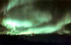
MASSIVE NORTHERN LIGHTS will be with us!
...and then back to Toronto, or wherever.
WHEN?
The trip begins February 14, and is scheduled for 10-14 day�s depending on weather, offroading opportunities and lazy day�s.
DEPARTURE?
The group is leaving from Toronto Ontario, with a final destination at LG4 for a total of 2190KM each way.:
WHO?
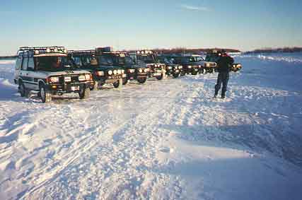
A group of three Land Rover Discoverys with Driver and co-driver. Two veterans from the last trip and one brave new team from the US.
Vehicle 1:
Co-Driver- Mary Kaye
Ted and Mary were the driving force behind the first James Bay trip, and again this year, Ted is the one responsible for the spark to get this expedition under way.
Vehicle 2:
Yours truly, and Cindy were also part of the last James Bay expedition. Looking forward to another great trip especially finding the large herd of caribous.
Vehicle 3:
Mickey and TJ�s first reaction to the proposed trip was "We would be more into it if you could guarantee some camping". This should be fun.